
Introduction
Why use a threat-based approach?
This tool is designed to rapidly assess and manage perennial and intermittent lotic (flowing) water systems. Lentic, or still-water, systems, such as wet meadows, swales, seeps and marshes, are inherently different.
This guide is not an instruction manual but a decision-support tool for understanding how riparian areas such as creeks, rivers and streams should function. This guide helps managers determine whether a riparian area is functioning properly and how to restore or maintain proper function. A wide variety of natural resource professionals or land managers will find this guide helpful because it provides a framework for land managers to identify, discuss and address threats to riparian resources.
The goals of this tool are:
- Facilitate communication about riparian conditions across a broad audience of stakeholders.
- Provide an assessment that easily integrates with existing protocols and programs.
- Help users identify factors impacting stream resilience.
- Help users assess and prioritize areas that may require more detailed investigation.
This tool doesn’t replace more detailed riparian assessments that may require experts from multiple disciplines (such as Proper Functioning Condition). Rather, it complements these more time-intensive quantitative/qualitative assessments by providing:
- An initial evaluation of existing conditions using terms and concepts that are easily communicated to a diverse audience.
- An assessment of stream system resilience.
- A guide to combining #1 and #2 to assess and prioritize management needs.
The ecological categories in this tool don’t represent every possible landscape condition. Rather, these categories present a simplified approach for capturing most conditions land managers are likely to encounter and grouping these conditions into logical ecological states with similar attributes and management needs. This model helps managers identify primary threats to stream condition and resilience and helps determine when to involve riparian experts to guide land management decisions to maintain or make progress towards the desired condition.
Who can benefit from this guide?
The complexity of ecological systems leads to three broad tiers of understanding (or “management awareness”) within and between groups of people.
- Tier 1: A person who is concerned about riparian resources but has limited to no knowledge about riparian ecology.
- Tier 2: A person who knows that there is something wrong or right with the riparian resource and understands the general management needed to fix or maintain a riparian system. Complex treatments typically require someone with more detailed knowledge of riparian systems (see Tier 3 below).
- Tier 3: A person who knows what is wrong or right with the riparian resource and can produce a specific management prescription to either fix or maintain it in the desired condition.
When it comes to riparian systems, most members of the general public have a Tier 1 level of awareness. Upland land managers generally fall into Tier 1 or sometimes 2, but are often intimidated by complex riparian systems. Tier 3 includes people who conduct research and develop detailed tools (such as the Rosgen stream classification system, the stream evolution model, Great Basin watershed and ecosystem assessment products) that increase our knowledge of riparian ecosystems. However, these technical guides are often needlessly complex for Tier 1 observers and Tier 2 managers, both of whom are critical to solving large-scale riparian issues.
Tools that foster riparian ecosystem understanding and management can help increase the number of Tier 2 managers. This Manager’s Guide is one such tool. It targets Tier 1 individuals and gives them the skills and vocabulary to assess common stream conditions, ecological threats and risk factors. With the background provided by this tool, Tier 1 individuals become more confident and experienced Tier 2 managers.
This guide does not include the Tier 3 level of complexity necessary to formulate complicated stream remediation. Instead, it focuses on a Tier 2 level of understanding of basic riparian attributes that can be communicated to broad audiences yet inform meaningful management.
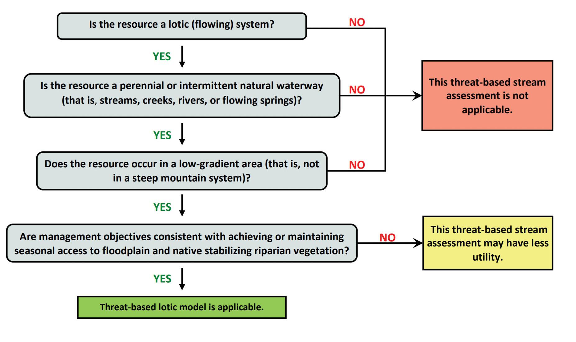
Where this guide applies
This guide focuses on stream systems within sagebrush ecosystems of the Pacific Northwest. However, the general principles we describe may apply to stream resources outside of this area.
This guide was developed for most low- to moderate-sloped perennial systems typically with year-round water as well as “intermittent” waterways that have flowing water only for part of the year but can develop and support streamside plant communities. This guide does not apply to steep, mountainous areas or boulder- and bedrock-dominated systems. This guide also should not be used for irrigation ditches or streams bound by levees. It may be less useful for managers who don’t want to maintain a stream’s access to a floodplain, such as when there are conflicts with adjacent infrastructure (Figure 1).
Seasonal considerations
This guide describes common visual clues that indicate a stream’s ecological condition. However, keep in mind that seasonal conditions can influence your observations. For example, during the growing season (generally April to September in sagebrush ecosystems of the Pacific Northwest, depending on elevation), vegetation is readily identifiable and intermittent streams are typically flowing. You can see evidence of the bankfull flow (the maximum amount of water a stream can carry without overflowing) and visually determine if overbank flooding is or has occurred. During higher flows, however, it may be more challenging to evaluate stream bank and channel characteristics and the stream’s year-round water availability. Visiting streams later in the season can help you understand how flow conditions influence streamside vegetation and guide expectations for vegetation potential. It’s best to observe the stream during multiple flow conditions. Understanding whether a stream flows on a perennial or intermittent basis is also critical, regardless of the season (see “Understanding relevant ecology”). Use caution when evaluating streams outside of the growing season, when water is absent, or immediately after a high-flow event. Take additional time before and during site visits to determine if the stream is perennial, intermittent or ephemeral. (Ephemeral means that the stream only has flowing water for short periods; see “Define assessment area and delineating stream reaches”).
Where do meadows fit in?
Meadows contain still, standing or slow-moving water. They are associated with a shallow water table and slow-moving surface water and may occur in conjunction with streams, creeks and rivers. They are a critical and productive component of sagebrush ecosystems and deserve management attention. However, they also occur away from flowing systems, such as in seep areas around springs, moist swales or high-elevation settings, and this guide is not designed for those types of meadows.
When meadows occur adjacent to a stream, their condition is almost always dependent on the stream’s condition. For example, a functioning stream system with sufficient native stabilizing riparian vegetation and an unimpaired channel helps maintain the near-surface water table that sustains an adjacent wet meadow. This guide can help you determine how the stream’s condition may be affecting the adjacent meadow’s health.
Wet meadows can change dramatically from site to site, yearly and seasonally. In short, land managers can expect to encounter landscape complexity in the form of spatially and ecologically intertwined lentic and lotic systems. In these instances, it’s important to carefully consider where this framework does — and does not — apply and to document your rationale. You may also need to consult assessment methods designed specifically for lentic systems.
Overview of method
Stream and river systems in the sagebrush ecosystems of the Pacific Northwest face numerous risk factors that destabilize and compromise ecological function. Land managers must work at large spatial scales with limited resources to address these risk factors.
This guide provides a framework for natural resource professionals and land managers to identify, discuss and address risk factors and associated threats to perennial and intermittent flowing systems.
This approach follows these steps:
- Understand the relevant ecology. This guide uses functional vegetation groups and physical stream characteristics to describe ecological states and assess apparent trend.
- Understand risk factors and threats. Multiple factors can impair a stream channel and reduce native riparian vegetation — the two overarching threats to stream resilience.
- Define assessment area and delineate stream reaches. Desktop tools and onsite evaluations help you identify landscape-scale factors and determine which stream sections (called reaches) to examine more closely.
- Determine ecological states and assess apparent trend. Understanding the ecological state and assessing apparent trend help to determine stream resilience. This step addresses the questions, “Where are we now?” and “Where will we likely be in the future if we continue current management?”
- Consider conservation measures to achieve desired outcomes. Step 5 informs the tools and tactics needed to facilitate desired outcomes. Further investigation may be needed to understand the current condition and the specific management actions required. Conditions and action steps vary according to site characteristics and the land managers’ values and objectives.
Step 1: Understanding relevant ecology
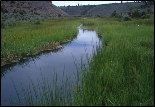
A functioning stream system supports sufficient native stabilizing riparian vegetation, possesses an unimpaired channel or channels, has regular access to its floodplain and an adequate water table to sustain native riparian plants. We define a stream system’s ecological function as a) the degree to which it can regularly access its floodplain, b) has a high enough water table to support native riparian vegetation across much of the floodplain and c) has sufficient native stabilizing riparian vegetation to prevent channel degradation. See Figure 2 for visual representations of these key features.

Sufficient native stabilizing vegetation and unimpaired channels allow the system to dissipate stream energy, especially at high flows, deposit sediment and maintain good water quality. These attributes affect nearly all management uses and values, including fish and wildlife habitat, forage production and reduced erosion during high flows. With these features, a stream is resilient to fluctuations in sediment and water supplied by the watershed. A resilient stream with these basic ecological processes supports the species-specific habitat requirements that foster plant and wildlife biodiversity. That said, our definition for ecosystem function excludes species-specific habitat characteristics because focal species and their habitat needs vary from place to place.
To rapidly assess the ecological function of stream systems, this framework uses a suite of easy-to-observe physical characteristics based on stream flow, vegetation functional groups and stream channel impairment (inadequate water table or lack of access to floodplain). This approach is most applicable to low- to moderate-gradient streams and rivers, with beds composed mostly of gravel and sand, fine sediment, or a mix of sand and fine sediment. Many of the sagebrush ecosystem stream systems in the Pacific Northwest have these characteristics. This framework is less applicable to steep, high-energy streams, with stream beds composed of large cobbles, boulders or bedrock, in confined mountain valleys (see Figure 10).
Stream flow permanence
This framework primarily applies to perennial and intermittent stream systems with permanent or semipermanent flow. Perennial streams flow continuously throughout the year, though their water levels usually fluctuate in response to the season, precipitation and drought. Intermittent streams only flow part of the year, often seasonally, when they receive water from seasonal springs or from a surface water source, such as melting snow. Perennial and intermittent streams typically have visible characteristics that reflect the permanent influence of water, such as surface flow, well-defined channels with banks and floodplains, or the presence of riparian vegetation. However, these characteristics may be less obvious or well-developed in intermittent systems. Different streamside plants are to be expected depending on the consistency and quantity of water in the system. If the stream you’re assessing does not have water, check with the local land manager to learn if it ever has water. Also, look for flow debris, native riparian vegetation or other signs of intermittent flow. These clues are detailed in subsequent sections. Also, look for management practices (such as irrigation and water storage) or upland conditions (such as conifer encroachment) that may cause a perennial stream to appear intermittent. This framework’s application is more straightforward with perennial streams, and additional consideration and documentation may be required to interpret the condition and potential of intermittent streams. This framework is not intended for use in ephemeral systems, which only flow in direct response to precipitation events and typically lack water-dependent vegetation and a defined floodplain.
This framework does not apply to springs — many of which are seeps or small pond-like depressions — but it may apply to predominantly spring-fed stream systems, such as flowing springs that supply enough water to sustain the stream characteristics described above.
Channel impairment
This framework relies on easily observed physical characteristics to evaluate whether a stream system is experiencing, or is at risk of, reduced floodplain access, a lowered water table or both. Due to natural variability, these indicators may present differently or may be absent entirely in some stream systems. In some instances where indicators are absent or conflicting, management decisions will likely require a more nuanced understanding of riparian ecology.
Headcuts: What are they? Why are they bad? How do you recognize them?
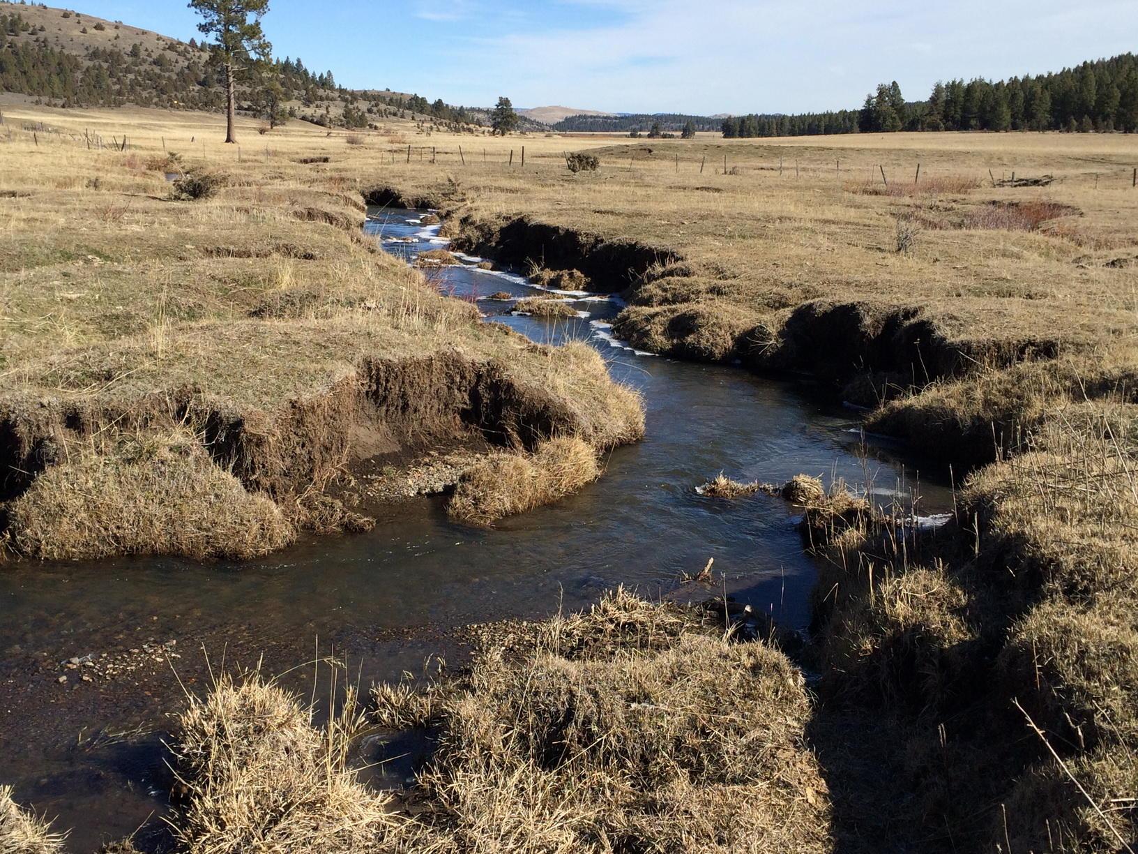
A headcut is the point at which a stream is transitioning between more deeply incised and less incised portions of a stream (top photo). Headcuts are the upstream migration of an incised channel with the “head” at the upstream side and the “cut” at the point of erosion or cutting. Headcuts can result when the stream channel is incised by flood events, culvert failures, channelization (the act of straightening, redirecting or otherwise combining or confining natural streams in an artificially modified, reinforced or constructed channel), improper road drainage or from decreased vegetation cover. Actions that concentrate and confine stream flows can increase stream velocity and energy. If the stream energy cannot be dissipated on floodplains or by eroding laterally into the banks, this energy may scour the streambed, creating headcuts. Headcuts migrate upstream, eroding the channel vertically until they reach a nonerodible surface (see middle photo), resulting in an incised channel downstream.
Incised channels have reduced access to their floodplain and often narrow the riparian area. As the incision increases in severity, the ecological state of a stream changes from channel impaired to degraded (for more information, see Step 4).
Note that headcuts should be distinguished from naturally occurring plunge pools (see bottom photo). Plunge pools are mostly static in their location. They may look like a headcut but occur where water flows over rocks or logs, causing a localized scour (pool) immediately downstream. They do not migrate upstream, nor do they result in channel incision or reduced access to the floodplain.

Access to floodplain
The floodplain typically presents as low-lying land surfaces adjacent to a stream (Figure 2). Floodplains allow streams to disperse and slow floodwaters, leading to the deposition of fresh sediments and nutrients. Healthy floodplains are often important areas for forage production and wildlife. When streams have access to their floodplain, they can dissipate flood energy via overbank flow. This reduces the damaging impacts that occur when flood energy is confined within steep banks. In resilient systems, the active floodplain is fully inundated regularly. Typically, this occurs annually during peak runoff events but may occur anytime throughout the year when flows are high. The floodplain can also become saturated when underground water elevates the water table. Floodplain inundation usually occurs for a few days or weeks, but floodplain saturation — or the presence of abundant below-ground water within the floodplain — can last for weeks or months. However, the floodplain may not be inundated or saturated at all or to a lesser degree during drought years. In addition to observing a stream system flood event, other visual cues — such as flow debris (pieces of vegetation and other items deposited during high flow events), native riparian vegetation established well beyond the stream channel, and lack of upland vegetation adjacent to the channel — suggest a stream has access to its floodplain. One general approach to assessing a stream’s ability to access its current floodplain is to imagine if a vehicle easily could cross the stream channel. Systems with steep, unstable banks are likely experiencing, or recovering from, reduced floodplain access. Channels flowing through thick herbaceous vegetation on low-gradient valley floors are more complex. They are often far deeper than they are wide due to the strong root systems of the plants (see Photo B in “Missing native woody riparian species?”). Headcuts, stream channel incisions or excessive stream-bank sloughing, fracturing or other instability also suggest the stream does not have regular access to the floodplain. These visual indicators are detailed in “Step 4: Understanding ecological states and apparent trend” Also, see “Headcuts – What are they? Why are they bad? How do you recognize them.”
Adequate water table
A water table is the boundary between the unsaturated zone and the saturated zone in the ground. Below the water table, groundwater fills any space between sediments and within the rock. Standing or flowing water occurs when the water table reaches the surface. Though the water table depth may fluctuate with the season, a functioning perennial stream’s water table typically stays within 30 centimeters (about a foot) of the soil surface during the growing season — high enough to sustain key native riparian plant species. A stream system’s water table may be compromised if native herbaceous riparian species are stressed or dying or grow only in a narrow strip along the stream channel. Encroachment of upland vegetation into the riparian area is another sign of a compromised water table.
Base flow refers to stream system water contributed by groundwater sources. Base flow is generally lower and more constant than flows from precipitation or snow melt.

Sufficient stabilizing vegetation and functional vegetation groups
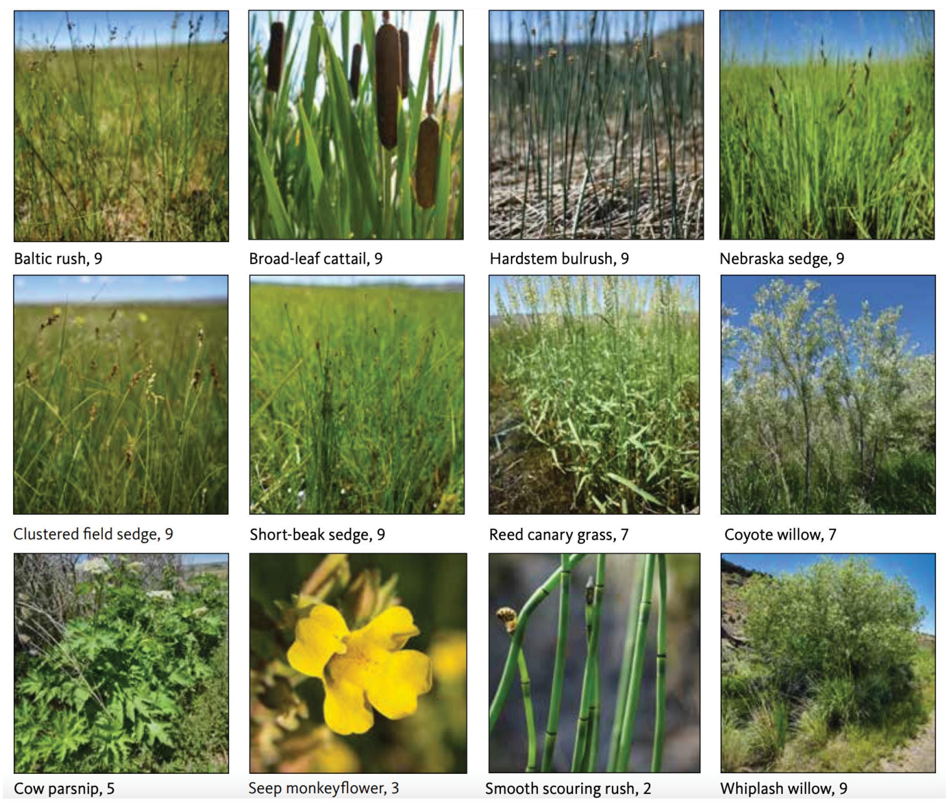
Functional vegetation groups are broad vegetative components of ecosystems that perform the same function or set of functions. Visually evaluating functional vegetation groups can be more efficient and less prone to observer error than approaches involving the identification of every plant species. Nevertheless, there is value in recording individual species when possible. In many cases, management decisions require knowledge of individual riparian species’ characteristics, such as their relative contribution to maintaining stream bank stability (“stability rating”), and their habitat value. For example, not all sedge species have the same rooting depth and bank-stabilizing capacity, and knowledge of individual sedge species can help you evaluate bank stability (Table 1, Appendix C). To assess riparian vegetation, this framework uses four different overarching groups:
- Native herbaceous riparian vegetation
- Native woody riparian vegetation
- Pseudoriparian vegetation
- Upland vegetation
Each of these groups is explained in more detail below. One additional category, “Other invasive weeds (upland and riparian),” is solely reflected on the field documentation form (Appendix B). This additional category prompts land managers to consider invasive or noxious weeds, which may require eradication because they are considered a public nuisance in certain jurisdictions. These noxious or invasive plants are typically managed on a species-specific basis, and such management recommendations are beyond the scope of this Manager’s Guide.
Streambanks are more stable and resilient during floods when they have sufficiently dense herbaceous and woody riparian vegetation. The amount and types of vegetation considered sufficient depends on stream characteristics. Excessive bare ground and litter — excluding anchored rock, bedrock or roots — are a concern in most systems.
Sufficient riparian vegetation slows flood water on the floodplain, reducing its energy and its ability to erode banks or harm vegetation. The complex structure of vegetation dissipates stream energy and velocity. Floodplains without sufficient vegetation are at greater risk of bank erosion, incision and vegetation loss in the event of high energy floods. You can think of water flowing through a stream lacking vegetation like a car driving down a paved highway and water flowing in a stream with sufficient stabilizing vegetation like a car driving off-road; the car and water can go faster with greater energy when nothing is there to slow them down.
| Common name | Scientific name | Greenline stability rating |
|---|---|---|
| Whiplash willow | Salix lasiandra | 8.5–9 |
| Baltic rush | Juncus balticus | 8.5–9 |
| Broad-lead cattail | Typha latifolia | 8.5–9 |
| Hardstem bulrush | Schoenoplectus acutus | 8.5–9 |
| Nebraska sedge | Carex nebrascensis | 8.5–9 |
| Water sedge | Carex aquatilis | 8.5–9 |
| Clustered field sedge | Carex praegracilis | 8.5–9 |
| Short-beaked sedge | Carex simulate | 8.5–9 |
| Geyer’s willow | Salix geyeriana | 8.5–9 |
| Red-osier dogwood | Cornus sericea | 8–8.5 |
| Coyote willow | Salix exigua | 6–7 |
| Woods’ rose | Rosa woodsii | 6 |
| Russian olive | Elaegnus angustifolia | 5–7 |
| Reed canary grass | Phalaris arundinacea | 5–7 |
| Streamside bluebells | Mertensia ciliata | 5 |
| Cow parsnip | Heracleum maximum | 5 |
| Sagebrush bluebells | Mertensia oblongifolia | 4 |
| Douglas’ sedge | Carex douglasii | 2–4 |
| Seep monkeyflower | Mimulus guttata | 2–3 |
| Common field mint | Menta arvensis | 2–3 |
| Kentucky bluegrass | Poa pratensis | 2 |
| Red top | Agrostis stolinifera | 2 |
| Smooth scouring rush | Equisetum laevigatum | 2 |
| Cheatgrass | Bromus tectorum | 1–2 |
Sources: Lorenzana, J.A., D.A. Weixelman and S.E. Gross. 2017. Plant Guide for Resource Managers: USDA USFS, Pacific Southwest Region R5-TP-042; Multiple Indicator Monitoring (MIM) of Stream Channels and Streamside Vegetation, Data Analysis Module Arid & WMV-2022; USDA-Plants Database plants.usda.gov.

Native herbaceous riparian vegetation
Native herbaceous riparian vegetation includes a variety of forbs, grasses, sedges and rushes (Figure 4 and C.1). Herbaceous riparian vegetation roots are relatively shallow but highly networked, providing cement-like stability to the upper portion of streambanks (Figure 3). Riparian species vary in their tolerance for wet or dry conditions. The most important riparian species have high moisture requirements and indicate an adequate, near-to-the-surface water table. These species — such as Nebraska sedge and water sedge — are known as riparian obligates (Figure 4, Appendix C). Riparian species differ in their ability to stabilize banks (see Table 1, Figure 4). Rhizomatous species — plants that reproduce primarily via dense, uninterrupted root mats — provide greater stability than herbaceous species that grow individually or in bunches. Additionally, herbaceous plants with deeper roots (greater than 30 centimeters or about 1 foot) typically provide more stability than a species with a similar growth form and shallower roots (Table 1). You can assess the species’ stability with a “tug test.” Grasp a stalk or handful of stems and try to tug the plant out of the ground. Under average moisture conditions — not extremely dry or wet — the ease or near-impossibility of this basic “tug test” can help you compare the differences in stabilizing capacity among various herbaceous species. Native herbaceous riparian vegetation will be nearly impossible to pull out of the ground, while plants that provide very little to no stability will be tugged out easily.
Native woody riparian vegetation
Native woody riparian vegetation includes willow, alder, dogwood and cottonwood. Woody riparian species stabilize banks and provide other ecological values. A mix of native woody riparian vegetation and native herbaceous species provides the best streambank stability (Figure 3). Willows have a deep rooting structure that stabilizes vegetated streambanks, similar to how rebar increases the stability of cement. However, not all stream systems possess woody riparian vegetation even under ideal management scenarios. The presence or absence of woody riparian species within grazing exclosures or landscape features, such as rock outcrops that limit grazing by wild and domestic animals, can provide insight into whether woody riparian vegetation was historically present in a given system, naturally absent or absent due to past or present management (see “Missing native woody riparian species?”). The abundance and diversity of riparian vegetation largely determine the stability of the stream system.

Missing native woody riparian species?
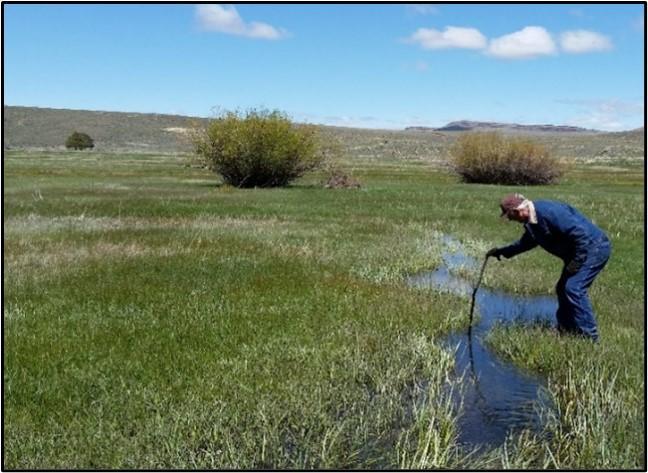
Willows, alders, dogwood, cottonwoods and other riparian native woody species require coarser stream substrates like sand, gravel or cobble, so they are less expected in lower-gradient systems dominated by finer substrates, like silt (see Figure 10). It has been said, “If you can hear a stream, it can support willows,” because streams with rushing water have a higher gradient and well-oxygenated coarser substrates (see top photo).
If a stream is missing native woody riparian species, how do you know if this is natural or not? Streams naturally dominated by native herbaceous vegetation — where willows may be expected in lower densities or not at all — typically have lower gradients with finer stream substrates (middle and bottom photos). In these “meadow stream systems,” herbaceous vegetation drives channel stability and channels are usually deeper than they are wide. In middle photo, a rancher is demonstrating the depth of a meadow stream channel. Although some willows are present, they are not expected to be a major component of the overall streamside plant community. Meadow streams are also unique in that they may be dominated by only one or two native riparian herbaceous species.
If you suspect a stream is naturally lacking woody species, ask yourself the following questions:
- Can you hear the stream? Typically, audible streams can support willows.
- Is it a meadow stream system (as in middle and bottom photos) where woody species may not be expected? Are the channels deeper than they are wide, with banks stabilized by robust native herbaceous species?
- Is the reach an area of fine soil deposits without sand or gravel needed for woody establishment?
- Do woody species exist upstream or downstream in the watershed or off-channel in the floodplain? For instance, are there woody species between rock outcroppings, or in areas where ungulates’ (hoofed mammals) access to browse is difficult or excluded?
- Are you aware of any historic management actions to eradicate willows or other riparian woody vegetation? In some drainages, efforts were made by land managers to eradicate willows and often those areas are still lacking willow recruitment.
Ultimately, if you believe that woody riparian vegetation is naturally absent, you may be right; there are situations where that is true, so answer the questions above and document your reasoning.

Pseudoriparian vegetation
Pseudoriparian vegetation includes common riparian imposters and invaders such as reed canary grass, tamarisk or Russian olive (Figure 5, Appendix C). This functional group includes herbaceous and woody species. Though these plants commonly occur adjacent to streams, they have a high tolerance for dry conditions and can mask channel impairment from a lowered water table or a lack of floodplain access. See “Reed canary grass, a pseudoriparian species.”


Upland vegetation
Upland vegetation next to a stream or in low-lying floodplain areas may indicate an inadequate water table, lack of floodplain access or both. Woody upland vegetation includes shrubs, such as sagebrush and rabbitbrush, and trees, such as western juniper. Herbaceous upland vegetation includes invasive annual grasses, perennial grasses (including Kentucky bluegrass) and many upland forbs.

Step 2: Understand threats: risk factors and processes leading to stream vulnerability
Threats to lotic systems
In this step, we describe in more detail the two primary threats to creeks, streams and rivers:
- Impaired channels
- Lack of native stabilizing riparian vegetation
To be resilient to fluctuations in sediment and flows, stream systems require intact channels, which provide access to the floodplain and a water table sufficient to support native stabilizing riparian vegetation. The lack of one or both of these critical characteristics indicates a stream system is severely compromised and risks losing management uses and value.
Impaired channels and reduced native riparian vegetation perpetuate each other. Once stabilizing vegetation is lost, streambanks are more susceptible to erosion that incises or widens streams and restricts access to the floodplain. Likewise, when impaired channels reduce floodplain access and the water table, native riparian vegetation is deprived of moisture, loses vigor and eventually dies (Figure 6).

When streams are incised and the water table is lowered, livestock and wildlife may not be able to access water. Certain agricultural practices, such as forage production, may no longer be supported within the riparian zone of the surrounding floodplain. When a stream becomes disconnected from its floodplain and the water table is lowered, riparian vegetation and adjacent meadows lose moisture, key plants and insect communities — all essential habitat components for wildlife. The habitat for aquatic species also suffers because less water in the stream threatens the persistence of overstory vegetation, increases water temperature, decreases dissolved oxygen and reduces habitat complexity.
Threat-based management focuses on the primary threats to riparian ecosystem function. This framework describes how primary threats compromise stability in creeks, streams and rivers and how management can influence them. By prioritizing the most pressing issues, managers can maintain, stabilize, improve or protect stream systems by focusing on the risk factors and associated processes that contribute to the expression of the primary threats.
Risk factors
Risk factors are events, actions or natural phenomena that can contribute or lead to impaired channels and reduced native stabilizing riparian vegetation. These risk factors intensify ecological threats through such processes as sedimentation, stream flow or erosion (see Figure 7). Threats and risk factors can also be located outside of the assessment area (downstream, upstream and even in forested and higher-gradient areas).

The following are some common risk factors for creeks, streams and rivers in Pacific Northwest sagebrush ecosystems.
Channelization
This is when natural streams are straightened, redirected or otherwise combined or confined in a modified, reinforced or constructed channel. Channelization encompasses a variety of approaches to streambank engineering, including the installation of riprap and the construction of berms to contain the stream’s flow. Streams may be channelized for irrigation, relocated to facilitate agriculture (such as when a channel is moved to one side of a valley bottom to create a hay meadow), or modified to reduce flood damage to roads, crops and other human infrastructure. Channelization reduces stream complexity and introduces many problems, such as disconnection from the floodplain and increased stream velocities and erosion, which can cause upstream headcuts. This degrades channels, increases channel depth and further restricts access to the floodplain. Reaches downstream from the channelized area may also be impacted by the resulting high-energy stream flow, excess deposition of sediment or bank instability. Such processes lead to the threats of channel impairment and native riparian vegetation declines. Lowered water tables and deeper channel depths can deprive stabilizing vegetation of needed moisture, leading to plant mortality. Channelization usually involves the removal of stabilizing riparian vegetation, which in turn increases the potential for erosion and can worsen or accelerate the loss of floodplain connectivity (see Appendix D, Figure D-1 for additional details).
Roads
Roads often act as ephemeral channels that rapidly deliver water to the stream system. Roads can change the location and rate of water flow within a watershed so that the peaks in runoff are higher and low-flow periods are longer. Roads in the floodplain can confine and limit stream meandering, making streams flow faster and erode more. Being largely impermeable, roads capture and concentrate precipitation runoff, leading to increased runoff velocity that can erode stream channels and cause headcuts. Drainage and road runoff can also increase sediment deposition in the stream. Undersized culverts at channel crossings concentrate flows, increase stream velocities and cause channel incision and erosion downstream. Roads that cross meadow systems often concentrate natural low-velocity flows from multiple channels into a single culvert, resulting in channel incision, a lowered water table and a dried-out meadow. Meadow-damaging roads can also impact groundwater dynamics, concentrating surface flows at culverts and depriving meadow edges of subsurface moisture. These groundwater changes damage riparian plant species along these dewatered edges. When riprap is installed along stream banks to protect roads, a stream’s energy is transferred downstream, often causing erosion elsewhere in the system (see channelization risk factor above). In summary, the concentration of flows and erosion resulting from roads increases incision, leading to an impaired channel that lacks floodplain access. Without access to the floodplain, riparian vegetation is replaced by upland species. Road maintenance, proper crossing and drainage design can help alleviate some of these impacts (see also Appendix D, Figure D-2).
Drought
Long periods of drought can deplete stabilizing riparian vegetation as the water table decreases. Depending on the severity of riparian vegetation loss, stream banks may become increasingly susceptible to erosion and the stream channel may eventually become impaired and lose access to the floodplain. Drought, when combined with dewatering from irrigation management (see below), can compound the process of a decreasing water table and loss of native stabilizing riparian vegetation (see Appendix D, Figure D-3).
Incompatible irrigation management
Irrigation can influence stream systems by decreasing the amount of water in natural channels, diverting flows into constructed channels or both. These artificial manipulations of flow affect the timing, quantity and pathway of water within the system. Irrigators often have the rights to completely dewater streams, leading to a lowered water table and native stabilizing riparian vegetation mortality. Tail water, which is surface water runoff often from a cultivated field returning to the natural channel, can carry excess sediment from irrigated fields, altering deposition patterns in the channel. The pathway where irrigation water rejoins the stream can become an unstable, erosive channel, increasing sedimentation to the stream or creek. Substantially increased flow (such as from a dam release) can cause erosion and localized degradation of the channel. That damage reduces access to the floodplain and deprives riparian vegetation of the moisture it needs to survive. For additional information, see the text box, “Flow regulation” and Appendix D, Figure D-4.
Dam failure
When dams fail, large amounts of water and sediment can be released into the downstream channel, causing severe erosion and capacity-exceeding sediment loads. Large dams rarely fail, but small irrigation dams and beaver dam failures can degrade local channels and affect the water table. Those conditions cut off access to the floodplain and deprive riparian vegetation of the moisture it needs to thrive (see Appendix D, Figure D-5).
Unmanaged or improperly managed grazing
Improper grazing can take many forms, such as season-long grazing along streams, overstocking and unlimited access to streams. Because ungulates are drawn to palatable, green vegetation along streams once upland vegetation has withered, repeated late-season grazing by livestock, deer, elk, and free-roaming horses can damage woody and herbaceous riparian vegetation. Additionally, the hoof action of ungulates can destabilize stream banks, damage established plants and cause erosion, all of which are processes which create an impaired stream channel. If not addressed, associated erosion widens the channel, which lowers the water table and can lead to lost riparian vegetation and impaired channels (see Appendix D, Figure D-6 and “Putting risk factors together — a real world example”).
Wildfire
Healthy streams are often resilient to wildfire because riparian vegetation will recover quickly. However, fire along streams with insufficient riparian vegetation prior to burning can cause the stream to decline because fire-induced plant mortality reduces bank stabilization, causing erosion. In addition, fires in the surrounding upland watershed may result in hydrophobic, water-resistant soils and temporary loss of soil stabilizing upland herbaceous and woody vegetation. The resulting conditions, combined with environmental factors (such as rain, snow or wind), can lead to increased and flashier runoff. This accelerates erosion and deposition, especially in less-than-functional stream systems, which can result in channel impairment, the loss of stabilizing riparian vegetation or both (see Appendix D, Figure D-7).
Degraded uplands
In general, healthy uplands are a vital component of a healthy watershed. Healthy adjacent uplands help maintain water tables and moderate sediment and surface-water inputs in riparian systems. Unhealthy adjacent uplands can cause “flashy” flows that add uncharacteristically high inputs of sediment and surface water.
Degraded sagebrush-bunchgrass uplands can alter the soil-moisture regimes and available water to the stream. For instance, widespread juniper expansion in the uplands decreases below-ground water input to the stream. This reduced water availability can deplete riparian vegetation and make systems more vulnerable to erosion, causing impaired channels and reduced floodplain access.
Degraded uplands with excessive bare ground or shallow-rooted invasive annual grasses can cause high upland runoff and erosion. Bare ground can result from dense conifers in the uplands, which outcompete herbaceous upland vegetation, or other stressors such as unmanaged grazing. Loss of the upland understory can increase soil erosion, overland flow and flash flows of water and sediment into streams. Runoff from the degraded uplands often leads to more water moving at higher velocities through existing channels. That high-velocity runoff often leads to headcuts, a characteristic of channel impaired streams (see Appendix D, Figure D-8). Moreover, uplands dominated by invasive annual grasses are more wildfire-prone, increasing the potential for wildfire-associated processes. For additional information about upland threats, see Threat-Based Land Management in the Northern Great Basin: A Manager’s Guide (see Appendix A).
Putting risk factors, processes, threats and conservation
together: a real-world example
Unmanaged grazing by concentrated populations of free-roaming horses or burros may be a risk factor in a given stream system. A resulting set of processes that may be set into motion include plant mortality, reduced plant diversity and recruitment, and ultimately a loss of stabilizing riparian vegetation (threat). When native stabilizing riparian vegetation is lost in a stream system, it is typically replaced by less stabilizing species that are more tolerant of lower water tables and dry soil conditions. This, in turn, can facilitate erosion (process), leading to a loss of floodplain connectivity and degrading the channel (threat). Managing herd size, movements or both are examples of broad conservation measures (see Figure 7) to address this risk factor. More specifically, site-specific management actions may include reducing herd size or developing off-site water sources and fencing to protect streamside vegetation.

Step 3: Define the assessment area and delineate stream reaches
The following section will help you find a balance between what is feasible — in terms of targeted field efforts — and what might be considered ideal — visiting every square foot of a given stream system. To land on a survey approach that is practical and ecologically defensible, consider how much of a stream should be surveyed and which stream sections or assessment reaches must be considered separately. A single assessment reach is a stretch where most factors (described in detail below) influencing stream conditions are comparable. Survey as much of the stream system as feasible; overlooked risk factors might develop into less-manageable problems and system degradation.
Even if your assessment area is limited or influenced by other management zones, the factors below are useful because conditions outside of your assessment area could influence your site of interest. When assessing larger areas, consider how stream conditions and context can change significantly within a short distance. Isolated problems may require breaking a stream into several different assessment reaches. The number of discrete assessment reaches you determine depends on observation of significant changes in topography, vegetation, hydrology, management and infrastructure (see Figure 8). If dissimilar assessment reaches are inappropriately lumped, you may miss important contextual clues for understanding system function and threats or make inaccurate assumptions about unvisited areas. In some instances, small inclusions of unlike conditions may be grouped within a single reach if the nature of and rationale for these inclusions are documented.
Because it may not be possible to designate an unlimited number of assessment reaches or to survey the entirety of all the streams on a property or within a management area, the considerations below can help determine specific locations to visit (see Figure 8).
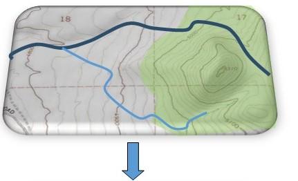
Figure 8. Example of the process of delineating assessment reaches.
Notice the varying topography and vegetation on the landscape, with steeper areas with tree cover to the east and sagebrush flats to the west. Consider evaluating each geophysical area separately. Notice, too, that the property has a main stem and a tributary; evaluate each stream type separately.
Now consider land uses and management. The property has two pastures with different grazing regimes that may have unique influences on the stream conditions. You may wish to evaluate stream length within each pasture separately.

Man-made infrastructure like roads, culverts and irrigation diversions may alter stream conditions. Consider assessing stream reaches above and below these infrastructure features.
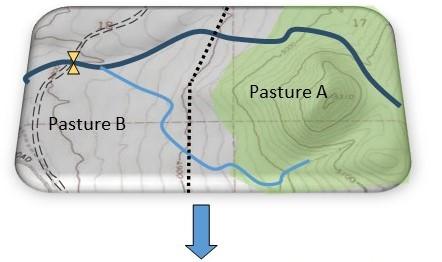
As a general rule, within each stream reach, management, landform, vegetation and hydrology should be relatively consistent. Considering features and management differences in this example, multiple assessment reaches are warranted. This ensures that observations within each “sub-sampled” survey area can be generalized to its respective stream reach with confidence.


Office work to be conducted in advance of a field visit
Before going into the field, familiarize yourself with the areas to be surveyed. Include areas upstream and downstream that may be influencing the survey area — such as upstream diversions and dams, or downstream areas of incision. This can be accomplished by using Google Earth or Geographic Information Systems (GIS) and by reviewing pasture maps, historic satellite imagery and hydrology data. Ask the land manager about the quantity, persistence or seasonality of water in the stream. The land manager may alert you to resource concerns that you may want to visit in person. The factors listed below can help determine where to create reach breaks and prioritize areas for site visits and assessment.
Management
Stream conditions are often related to management differences throughout the stream system. We recommend visiting a stream in every pasture it traverses. Review maps and data before your visit, but also ask the land manager or landowners about management actions that may influence stream condition. Does the stream cross pastures under significantly different management (grazing season of use, stocking rate or duration; irrigated versus nonirrigated)? Does an irrigation canal or similar structure divert water from the stream? Are there any dams, reservoirs, stock ponds or other flow barriers influencing the system? With each significant change in management, a new assessment reach may be warranted if those changes alter site conditions.
Local knowledge
Ask the land manager if stream conditions change, such as going from continuous to intermittent flow during hot months. Are there areas in good, bad or otherwise noteworthy condition? Are there areas of active beaver use or excessive wild, feral or domestic ungulate use? Such areas likely warrant further investigation to inform relevant management actions.
Topography
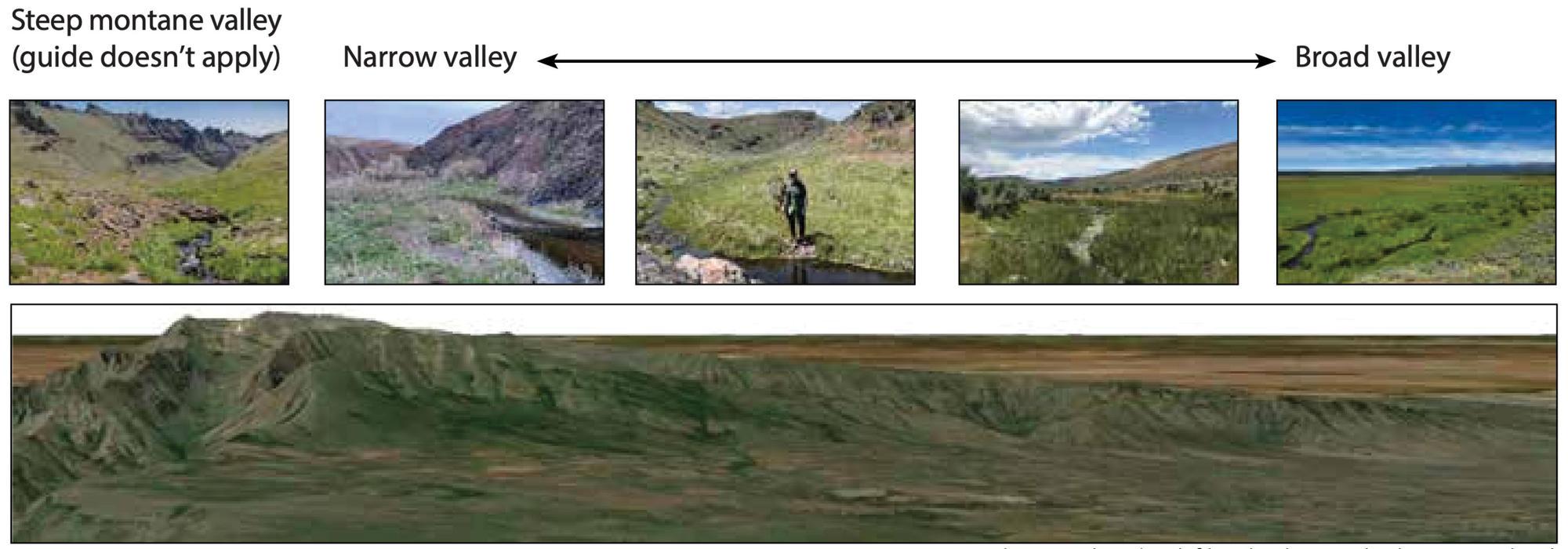
Does the topography around and along the stream change significantly? Stream characteristics may change as the surrounding landform changes and topographic changes may call for separate assessment reaches. Does the stream go from a narrow valley confined between hillslopes to a broad valley? A stream in a narrow valley has less room for lateral movement and would typically have a small floodplain. Conversely, a broad valley may allow for more lateral channel migration and have the potential for a larger floodplain. Canyon walls bound streams and restrict lateral movement or floodplain development. See Figure 9 for examples of different valley forms.
Vegetation
Does the vegetation around the stream change significantly? For example, does the stream travel through sage steppe into a woodland or grassland? Major changes in vegetation may result in dissimilar stream conditions that should be considered within distinct assessment reaches.
Hydrology
Does the reach include a tributary junction? A tributary joining a stream typically marks a new assessment reach because tributaries may add water, stream energy and sediment to the main stem.Consider designating separate assessment reaches above and below confluences. Does stream flow change from intermittent to perennial? If stream flow changes, vegetative and channel characteristics will likely reflect those changes and require a reach break. Is there a dam, reservoir or diversion that reduces or alters flow? Is stream flow supplemented by returning tail water or irrigation? These changes must be considered and could designate a distinct assessment reach (see “Flow regulation”).
Infrastructure
Consider infrastructure when determining assessment reaches. Does the stream run adjacent to a road, or does a road cross the stream? A stream adjacent to a road may be influenced by added runoff or its floodplain may be constrained. Likewise, a stream often changes character at road crossings.
Observe the stream at every road crossing. Other infrastructure, such as constructed berms to protect fields, often influences the stream channel. Designate separate assessment reaches when infrastructure has a significant influence. For example, the reach above a road crossing should be separate from the reach below.
Field determination
Field visits may reveal stream conditions or context not apparent from office-based investigations or discussions with landowners and managers. In the field, stay alert to changes in stream gradient, dominant substrate or valley form (topography) and note any corresponding changes to stream condition. If you note a distinct difference or change in conditions while in the field, consider creating a reach break. Also, designate a new assessment reach if you observe consistent changes in the stream’s ecological state.
Changes in stream gradient
Even slight slope changes of 2% to 4% affect water velocity, material transport and floodplain access. All else held equal, lower slopes are associated with low stream velocities, deposition of finer materials and the potential for greater floodplain access and sinuosity, which is the curviness of a stream when viewed from above. The converse is true of steeper slopes. See Figure 9 for examples of different stream gradients. Changes in the stream gradient can help explain field observations. For instance, as a stream shifts from a low to a high gradient, the floodplain width and riparian area narrow. This narrowing may be due to the landscape rather than a sign of stream degradation. An abrupt change in the stream gradient could be a sign of degradation. For example, a headcut can increase the gradient by reducing the natural meandering of the stream system.
Changes in dominant stream substrate
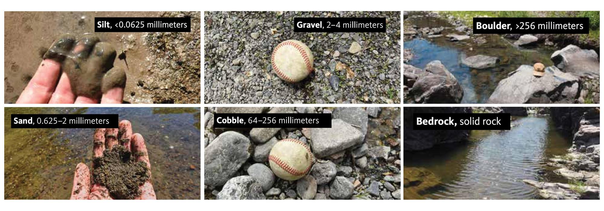
A shift in the dominant substrate along a stream bottom (excluding pools) may indicate a significant change in water velocity and may necessitate the designation of a separate assessment reach. Finer materials, such as clay, silt and sand, characterize slow-moving stream reaches. Increasing stream velocity corresponds with larger substrates, such as gravel, cobble, boulders and bedrock (see Figure 10). Explore why a stream substrate changes. If you determine the change is related to surrounding topography, level of incision or hydrology, you may want to designate a new assessment reach. Focus on the substrate in faster-flowing stream sections rather than pools, which have deeper, slower-moving water and typically have different substrate materials than the adjacent flowing areas.
Changes in topography
Topographic changes (such as in valley width, slope or both) are related to a stream’s potential for lateral movement and access to the floodplain. While topography may be discernible using GIS or Google Earth, certain important topographic changes are only apparent in the field. It may be difficult to assess the valley shape from satellite imagery, but field observations make that shape more apparent. A broad valley is generally at least 10 times the width of the stream channel, while a narrow valley will be less than 10 times the channel width. Changes in landform, like valley width, can affect stream condition. A change in stream condition due to topographic variance may warrant the delineation of a new assessment reach. Stream condition changes could be due to topographic changes rather than management actions or other risk factors. See Figure 9 for examples of different valley forms.
Changes in vegetation
Although obvious vegetation shifts can be identified using GIS or Google Earth, a site visit will provide more accurate observation. Changes in vegetation, such as when willows transition to cottonwoods or sedges and rushes transition to willows, could indicate changes in gradient, topography, soils, hydrology or management. When you see a vegetation shift, evaluate the larger landscape for clues why the vegetation is changing and determine if a new assessment reach should be designated.
Documentation
On each documentation form (Appendix B), clearly justify the number and location of distinct stream reaches. If you can’t visit a substantial portion of a reach (more than 30%), measure the length of the reach visited and note your confidence concerning areas you were unable to observe.
Step 4: Understand ecological state and assess apparent trend
Understand states
Within the context of the two primary threats, this framework uses a decision tree (Figure 11) to depict five different ecological states.
- Functional
- Recovering functional (historically incised)
- Channel impaired
- Vegetation impaired
- Degraded

Each state, described in detail below, represents a point-in-time status of a stream across an infinite continuum of possible stream conditions. Figure 12 illustrates some of the key features that help distinguish differences between ecological states. Ecological states are generalized descriptors of the current stream status.

Functional
A stream in the functional state has unrestricted access to the entire floodplain from valley wall to valley wall during high flows. At base flow (when the stream is sourced solely from stored groundwater, not precipitation runoff), the water table adequately supports native riparian vegetation beyond the stream banks. There should be no headcuts. Streambanks are dominated by native stabilizing riparian species (this does not include pseudoriparian species, such as reed canary grass or Russian olive) and, in some cases, anchored rock. The native stabilizing riparian vegetation present includes multiple species with several age classes. Not all functional streams have (or historically had) large native woody riparian vegetation (see “Missing native woody riparian species?”). However, if the site potential is appropriate, a functional stream would likely have multiple age classes of native woody riparian vegetation, except for alder-dominated systems where single age classes are common. Upland vegetation is not encroaching on the floodplain. The channels have space to move freely, demonstrating sinuosity, unless the channel is naturally restricted by topography, such as canyon walls. There is no evidence of historic incision. Functional stream channels do not occur within an inset floodplain bounded by broad, flat upland terraces, which represent the historic floodplain prior to past incision events.

Recovering functional (historically incised)
This state occurs after historic degradation. The stream has access to a new inset floodplain that is different from and narrower than the historic floodplain (see sagebrush-covered bench towards the top of the photo above). The historic floodplain now presents as flat upland terraces bounding the stream system. Within the inset floodplain, the stream is sinuous and may have point bars, but shows no active down-cutting and supports multiple age/size classes of native stabilizing riparian vegetation, including native woody species. There are no upland species present in the new floodplain, but they occupy the historic floodplain on the terraces. Through time and continued management, this stream should expand its floodplain, though it may not reach the extent of its historic floodplain without major and intensive restoration efforts.

Channel impaired
An impaired channel may have active headcuts, excessive erosion, steep stream banks and other signs of incision. The failing and incised bank in the photo above is an example.
An impaired channel also reveals subtle vegetation clues. While native woody species and some native herbaceous vegetation survive, their persistence is threatened by a lowered water table and decreasing floodplain inundation. Native herbaceous riparian vegetation may appear stressed, with browning, curling stems and reduced flowering, or be limited to a narrow strip directly adjacent to the channel edge or both. Upland vegetation may be encroaching on the riparian area. Unless arrested, continued channel incision will lead to a degraded state.
Vegetation impaired
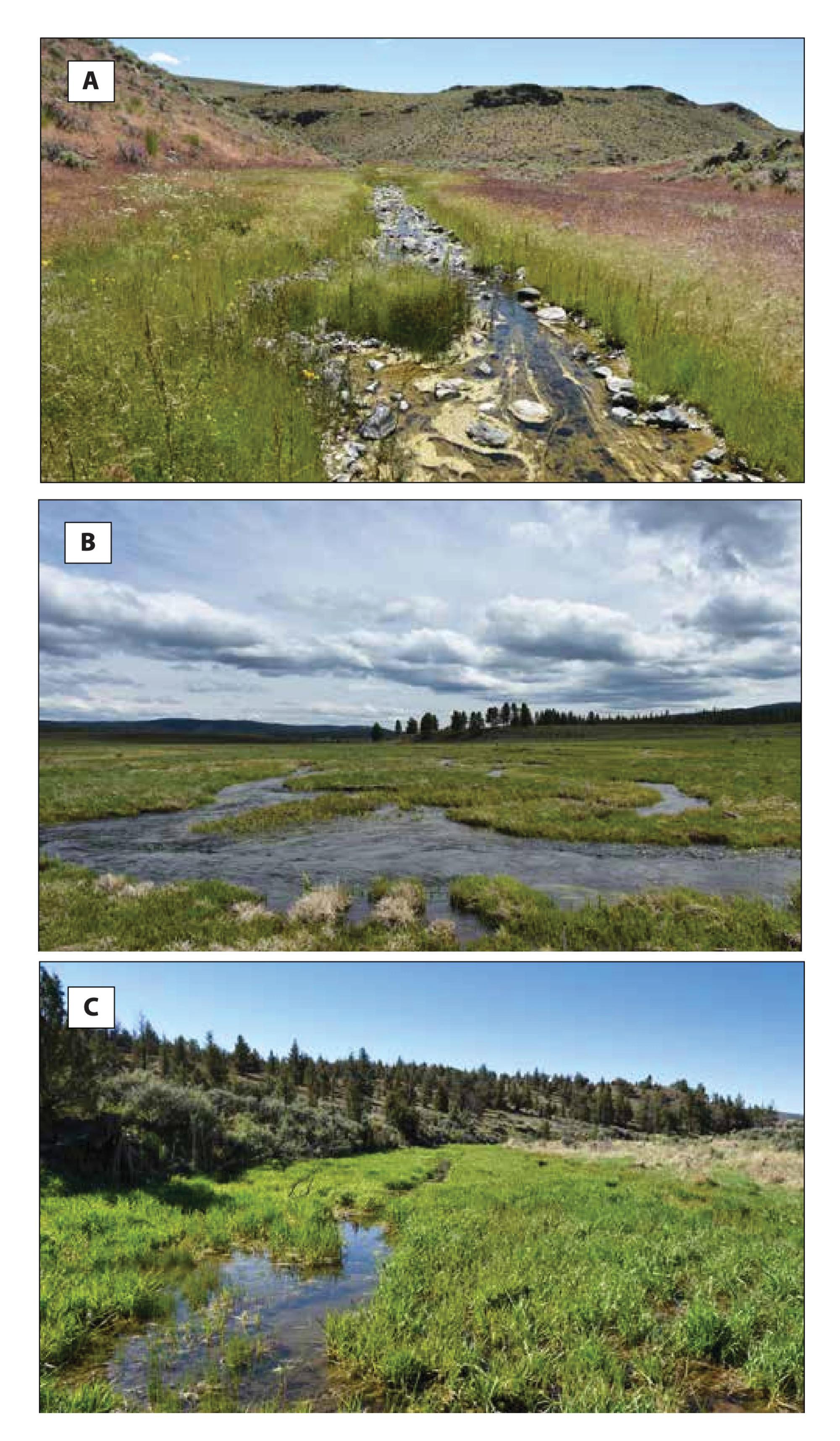
Vegetation impaired streams are not actively incising and have an adequate water table but lack sufficient native stabilizing riparian plants. Vegetation impaired streams may have sedges, rushes and other native stabilizing riparian vegetation in low densities, but bare ground, litter or upland or dry-tolerant species cover greater than 20% of the riparian zone (Photo A). Sufficiently dense native riparian species may be present, but they may have little to no recruitment of saplings or regeneration of rhizomatous plants. In a second scenario, a vegetation impaired stream may also lack woody riparian vegetation, even if the system has the potential to support these species (Photo B). In a third scenario, pseudo-riparian species like reed canary grass may dominate and exclude native riparian vegetation (Photo C). Though these streams feature an unimpaired channel or series of channels, if they lack stabilizing vegetation, they risk channel incision or excessive widening during a high-flow event.
Degraded
This state has a degraded channel and lacks sufficient native stabilizing riparian vegetation. This is an incised stream with steep banks precluding floodplain access. The water table at base flow is typically insufficient to sustain native riparian species, and upland vegetation is encroaching on the floodplain. The stream is restricted from accessing the floodplain due to downcutting, as opposed to natural features such as canyons. Native riparian vegetation is absent or limited to a very narrow strip along streambanks, and the system is likely devoid of most or all native woody riparian plants. Pseudoriparian vegetation may be present or prominent. There may be some mature native woody vegetation present, but seedlings and saplings are largely absent beyond the direct margins of the stream. There is likely evidence of active erosion, such as bank sloughing, and of past bank failures, where vegetation does not prevent erosion.
Mixed states?

Stream conditions occur along a gradient of change, and many sites might be logically and defensibly described by more than one state.
When a site fits in more than one state, ask yourself what management actions might best restore the site to a desirable state. The answer will help you classify the site.
For example, if a site needs fencing, changes in grazing management, riparian plantings or a combination of these actions, you could conclude the site is likely vegetation impaired. Once the state is identified, determine the cause of vegetation impairment before implementing management actions.
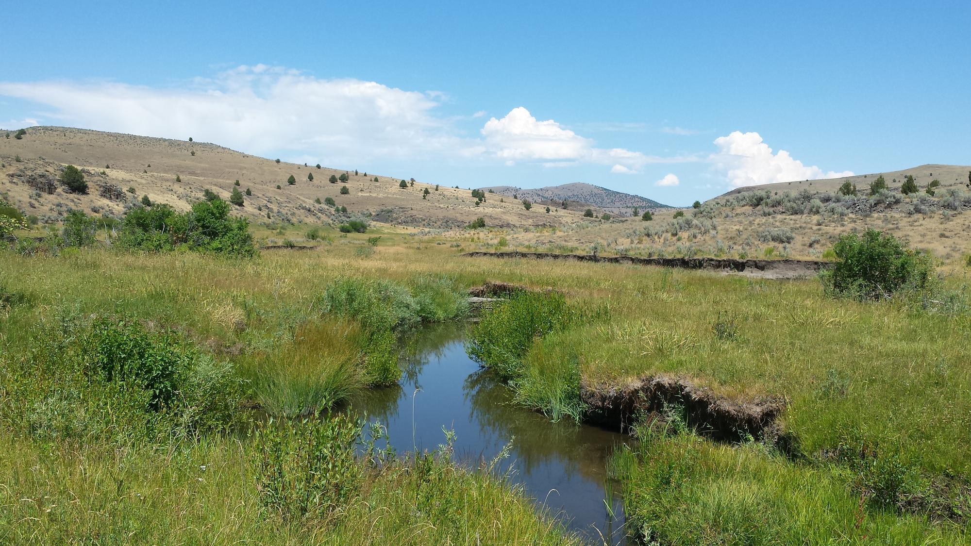
In all scenarios, select the best-fitting state, evaluate apparent trend and document your rationale. The ecological states within this framework are mental placeholders along a gradient of change. These placeholders help build a common vocabulary to talk about dynamic and diverse systems. The photo shows fairly common stream conditions that are representative of two ecological states.
This stream reach exhibits channel-impaired characteristics (notice incised banks in the background) with an upward apparent trend. You could also say it’s in a recovering-functional state with an upward apparent trend (developing floodplain access in the foreground and recruitment of native woody riparian vegetation). Regardless of which state is selected, it is more important to document the rationale for selecting one ecostate over the other.
Factors to consider when determining ecological state and assessing apparent trend
Considering ecological state and apparent trend together helps you determine, “Where are we now?” and “Where will we likely be if current management continues?” These considerations help you identify risk factors, develop appropriate conservation measures and prioritize restoration actions.
Apparent trend is a snapshot-in-time estimate of potential change in a stream system based on a variety of factors. Understanding actual change with certainty requires monitoring over multiple years, which can be expensive and time-consuming. However, multiyear aerial imagery — available via Google Earth Pro and other platforms — can indicate trends about floodplain inundation, riparian vegetation expansion or contraction and changes in woody vegetation. Estimating apparent trend involves assessing several different indicators, or factors that suggest likely change, and can inform management decisions when actual trend monitoring is unavailable or not feasible.
There are seven evaluation factors that will help you determine the ecological state and assess apparent trend of a stream system. The following discusses each evaluation factor and relevant visual indicators. Consider the results of all seven factors collectively — in addition to consulting the decision tree shown in Figure 11 and the reference image of key features of each ecostate in Figure 12 — when determining the ecological state and whether the apparent trend is upward, downward or inconclusive.
More frequent trend monitoring is needed if apparent trend is inconclusive. The full suite of visual indicators listed for each factor may not be visible within a given system. Written justifications for each factor are a central part of this process (see documentation form, Appendix B). Site-specific characteristics will influence each factor’s relative importance and local and expert knowledge can greatly improve the overall assessment.
Evaluation factor 1. Assess evidence of incision
Incision occurs when erosion lowers a streambed’s elevation relative to its floodplain. Streambed erosion generally occurs when any of the following are present:
- There is an increase in stream energy via more water or a steeper gradient.
- There is a reduction in sediment, such as when an upstream pond captures sediment normally transported through the channel.
- There is a decrease in stabilizing vegetation.
Incision, or active downcutting, indicates that a system is trending downward, towards a reduction in floodplain access.
Deeply incised channels have three major effects:
- Preventing overbank flows from reaching floodplains.
- Lowering the elevation to which groundwater drains, which further lowers water tables.
- Concentrating the stream energy in a smaller area increases the erosiveness of a given flow.
Streams that are incised such that the water line is roughly 1 foot (about 30 centimeters) below the top of banks have likely crossed an ecological threshold at which reduced floodplain access, lowered water table and riparian vegetation loss occur. Obligate native herbaceous riparian plants that have high and consistent moisture requirements (Appendix C: Riparian Vegetation) will suffer if the stream bank is 1 foot or more above the soil water table at base flows. That vegetation may only occur adjacent to the stream, if at all. Beyond the streambank, native riparian vegetation may show signs of browning, curling stems, reduced flowering and other stresses or become dominated by facultative herbaceous riparian species — plants that can persist in lower moisture conditions, such as Baltic rush or scouring rush (Equisetum spp.) (see Appendix C for more details).
Visual indicators of incision include headcuts, or streambanks that are steep and vertical. When evaluating headcuts in the field, it is important to distinguish active versus inactive headcuts, as this can be useful in assessing apparent trend. Active headcuts will migrate upstream until they reach a hard surface, such as bedrock or a road crossing where they are “arrested” and then considered “inactive.” To determine if a headcut is migrating upstream, place a reference marker on either side of the stream and measure progression during subsequent visits. Active headcuts or other evidence of incision likely indicate the stream is channel impaired or degraded.
When evaluating Factor 1, note pseudoriparian species, such as reed canary grass or more upland grasses like Kentucky bluegrass. These plants tolerate drier soil and can mask the full extent of incision-associated degradation. (See “Reed canary grass: A pseudoriparian species.”)
As streams recover, channels may occur within a new inset floodplain bounded by flat terraces vegetated by upland species (see Figure 2). These upland terraces were the stream’s floodplain before incision occurred (see Figure 12). When assessing Factor 1, be sure to only consider the degree of incision observed within the active channel relative to its current floodplain.
Evaluation factor 2. Assess evidence of streambank stability
In resilient streams, native riparian vegetation stabilizes banks against high flows. In some systems, bedrock, anchored rock or anchored wood help stabilize the bank. Adequate streambank vegetation cover helps disperse and slow floodwaters, dissipating energy and minimizing impacts to desirable stream characteristics. The loss of native stabilizing riparian vegetation increases the potential for erosion and bank instability and can lead to changes in the ecological state. Thus, stream banks dominated by stabilizing native riparian species with minimal bare ground may indicate a stable or upward apparent trend.
In typical healthy systems, bank instability is infrequent and limited; erosion primarily occurs on the outside bend of stream meanders or in the form of cutbanks in systems dominated by herbaceous vegetation (see Figure 2). Erosion along the straight stream segments between meander bends may indicate a downward apparent trend.
Stream banks collapse when gravity exceeds the forces holding the bank together. Signs of compromised bank stability include:
- Bank fractures, deep lateral cracks in the soil near the stream edge.
- Bank slumping, shearing or sloughing, where sections of the bank separate, topple and slide into the stream (see Figure 13).
- Large sections of exposed roots, especially those of herbaceous riparian species.
Any of these signs indicate declining or unstable banks and suggest the stream is in a channel impaired or degraded ecostate.
Signs that the banks may be vulnerable are:
- Excessive bare ground.
- Ground cover along stream bank dominated by upland species.
These signs indicate a vegetation impaired state with banks at higher risk of failure. Obvious signs of bank instability suggest the stream is already degraded.
Any of the five visual clues listed above are signs that the stream is trending downward.

Evaluation factor 3. Assess evidence of regular overbank flow
Stream systems must maintain access to their floodplain to disperse and slow floodwaters and dissipate energy. The floodplain encompasses low-lying land surfaces adjacent to a stream. In resilient systems, the floodplain is inundated regularly and for extended periods of time — at least once or twice every three years rather than only during outlier floods. Floodplain inundation and saturation occur when a stream tops its banks or when elevated flows raise the water table and add subsurface inputs, the latter of which is common in arid landscapes.
Indicators of regular overbank flow include:
- Fresh deposits of fine sediments beyond the stream banks
- Matted vegetation flattened in the downstream direction
- Recent flow debris piled up on the upstream side of trees, shrubs or fences. The pile can include finer debris like algae, leaves, and grasses in addition to coarse materials like sticks and branches that may persist more than a year after an outlier flood event.
These indicators typically become less obvious over time. It is critical to distinguish indicators of extreme flood events — high-water marks and large pieces of wood or debris — from the indicators noted above. Though these extreme event indicators may provide insight into the extent of the floodplain during outlier flood events, they are not necessarily good indicators of regular overbank flow.
Flow debris includes pieces of vegetation and other material deposited by water during a high-flow event. Flow debris is often wrapped around shrubs, trees or rocks with downstream flow direction evident in its orientation. The relative height of flow debris — whether it occurs around the base of shrubs or several feet above the ground — can indicate the magnitude of past flood events and provide insight into the variability of high-flow events in the system. The apparent age of flow debris can indicate when water last flowed across a floodplain. Recent flow debris might include green vegetation, indicating it was likely deposited within the previous year. The presence of finer materials that quickly degrade might indicate more recent deposition. Flow debris from different time periods may indicate that overbank flow occurs regularly.
However, it is important to note that there are certain streams (such as spring-fed streams without high seasonal energy inputs) that might not have overbank flow, but can support riparian vegetation through suburface flow. One visual clue that streams regularly saturate the adjacent riparian soil is when obligate riparian vegetation extends beyond the stream bank. That vegetation can indicate regular subsurface inundation of the floodplain and a persistent water table within a foot of the ground surface.
Signs of regular access to the floodplain indicate the stream is not channel impaired or degraded and may have a positive apparent trend.
Evaluation factor 4. Evidence of recruitment of woody species
While the presence of native woody riparian vegetation indicates a stream’s overall resilience, look for evidence that the woody vegetation is successfully recruiting new individuals to sustain its presence. A site with only mature native woody riparian vegetation that still has available space for saplings and young plants, but lacks evidence of their recruitment, may have a downward apparent trend. Look for evidence of browsing by livestock and other ungulates (deer, elk and feral horses) on woody species. If new growth is only above browse height, the animals are likely hindering recruitment. Excessive use by ungulates can weaken and eliminate woody plants. Multiple age classes of woody riparian vegetation indicate an upward apparent trend (see Table 2). Heavily browsed mature woodies may appear young because they are unable to grow above browsing height. Remember, not all streams support native woody riparian vegetation, even under ideal management scenarios (see “Missing native woody riparian species?”). Woody species recruitment helps you assess apparent trend, but it needs to be considered in conjunction with other factors to determine a stream’s ecostate.
| Number of stems at ground surface | Age class |
|---|---|
| 1 | Sprout |
| 2–10 | Young |
| >10, >½ stems alive | Mature* |
| >10, < ½ stems alive | Decadent |
| 0 stems alive | Dead |
*Some willows that are short in stature may at first appear young but are actually mature willows with >10 stems that have been heavily browsed.
Adapted from Winward 2000
Evaluation factor 5. Assess whether multiple native riparian plant species are present
Assess the diversity of species present in more than trace amounts. Stream resilience generally increases with vegetative complexity. Streams with inadequate stream bank cover (see Factor 2) generally lack a diversity of woody vegetation age classes (see Factor 4) and may have a limited number of riparian vegetation species present. Stream systems with multiple species of native stabilizing riparian vegetation can better withstand insect outbreaks, plant disease and grazing. These pressures often affect species unequally, so multiple species allow less-affected species to maintain channel and bank stability, store sediment and regulate water temperature. As a general rule, sites dominated by only a few native species, or that lack native woody vegetation where it occurs elsewhere (upstream or downstream where management may be different) may be in a vegetation impaired state, vulnerable to stressors and facing a downward trend. Multiple native riparian vegetation species in more than trace amounts indicate a more functional ecostate and positive apparent trend. There are some stream systems where one or two native riparian species provide stream resilience and stability (see “Missing native woody riparian species?” on page 13). Again, don’t include pseudoriparian or upland species, such as reed canary grass, Russian olive or Kentucky bluegrass, in native riparian diversity assessments. These species can outcompete native riparian vegetation, and though they may be abundant in the riparian vegetation zone, their ability to survive when the water table is unnaturally low may conceal incision or a lowered water table within a stream system.
Evaluation Factor 6. Assess riparian vegetation expansion and ratio to stream width
Factor 6 is more useful in assessing the apparent trend of a stream than determining its ecological state. Replacement of upland vegetation by native riparian vegetation is typically an indicator of riparian vegetation zone expansion and upward apparent trend. Upland vegetation may die or decline in abundance as the water table rises. This often occurs when a beaver dam complex raises the water table, allowing the native riparian species to replace upland species. Conversely, the presence of upland vegetation along the stream bank may indicate a downward apparent trend.
The outward expansion of native riparian vegetation often occurs as streams meander over time across their floodplain, eroding outside stream banks and depositing sediment in point bars (see Factor 7). In incised stream systems, this process can indicate an upward-trending stream establishing a new, inset floodplain as it progresses towards a recovering functional ecostate.
In some cases, a stream channel that is wider than adjacent riparian vegetation may indicate a downward apparent trend. Stream widening results from erosion, human or livestock activity, or mechanical means, and typically it has a negative impact. However, in some cases, stream widening is part of the natural channel-restoration process after incision has occurred (see “A note about the ratio of the width of stream channel to width of riparian vegetation” below).
Evaluation factor 7. Assess point bar formation and vegetation
Gravel or sand deposits on the inside of meanders or river bends are known as point bars, and their condition can be an indicator of apparent trend (see Figure 2). Point bars indicate that the stream is dissipating energy through sinuosity. This process is important to develop and maintain the floodplain. The absence of point bars doesn’t necessarily indicate a problem — for example, point bars may not be readily apparent in meadow streams (see “Where do meadows fit in?”).
Point bar slope can be another useful indicator. If a stream system has appropriate sediment and flow inputs, point bar profiles are gently inclined to moderately convex, progressing from the stream center towards the outer edge of the floodplain. This indicates an upward apparent trend. If point bars are completely missing or very steep, it might indicate a downward apparent trend with more sediment being eroded than deposited.
Point bar vegetation can also indicate channel condition. Upland vegetation on a point bar suggests infrequent inundation, which may mean the stream lacks access to its floodplain due to a lowered water table or channel impairment. In most resilient systems, point bars revegetate with native stabilizing riparian species such as sedges and willows. In most healthy stream systems, the water’s edge of the point bar will be vegetation-free but increasing native riparian vegetation composed of multiple age or size classes will be present moving further away from the stream.
How to consider ecostates and apparent trend with management opportunities and priorities
In this threat-based framework, ecological states are mental placeholders that serve as an effective communication tool to quickly convey the elemental features of an assessment reach. Ecological states should be based on current stream conditions, independent of site-specific management priorities, limitations and opportunities. For example, consider a hypothetical stream with an obvious incised channel because it has been straightened and confined to an artificially narrow floodplain adjacent to a permanent road. As we described above, incision is a characteristic of a “channel-impaired” stream. However, one might be tempted to classify this stream as “functional” with the awareness that moving the road out of the floodplain is not a viable management option in this hypothetical scenario and no further ecological uplift can realistically be expected. Doing so would present a very different and inaccurate picture of the stream’s actual condition. This stream reach should be designated as “channel impaired” or “degraded” (depending on vegetation) even though there may be few to no opportunities to enhance its condition

Considering ecostate with apparent trend can help you identify potential conservation measures and management actions (see Step 5) and prioritize which streams need management attention and with what urgency. For example, the hypothetical stream above would likely be a low priority for management intervention, particularly if its apparent trend indicates its condition is stable. Contrast that with a stream reach that is in a recovering functional state but has an active headcut that threatens incision and degradation and has a downward apparent trend. You might prioritize addressing the headcut with some urgency before the stream degrades further and restoration becomes more intensive and costly (Figure 15).

Step 5: Consider conservation measures to achieve desired outcomes
Depending on the current condition of a creek, stream or river, a land manager will either be interested in maintaining or improving its ecological state. When identifying conservation measures to achieve either of these two outcomes, managers should consider the ecological threats and risk factors at play in the system as well as the site’s apparent trend, alongside management uses and values. As shown in Figure 7, this guide considers a conservation measure to be an overarching strategy to address the primary issues that compromise a stream’s ecosystem function (threats). Conservation measures are informed by the risk factors that may be contributing to, or could potentially lead to, the future expression of the two primary threats. Management plans are a blueprint for the site-specific steps to enact conservation measures on the ground.
The connection between conservation measures and threats to flowing systems is discussed in “Putting risk factors, processes, threats and conservation all together – A real world example.”
Channel impairment and lack of stabilizing riparian vegetation — the two main threats to creeks, streams and rivers — are interconnected and often occur simultaneously. For that reason, conservation measures and related management actions may be applicable to both threats. We include a partial list of management actions below. Generally speaking, Tier 2 practitioners should enlist the help of Tier 3 stream restoration experts (and obtain permits from appropriate regulatory agencies as needed) when management actions will alter stream flow, channel structure or the floodplain. Management options that indirectly influence the stream typically do not require Tier 3 expertise prior to design and implementation.
To address a lack of stabilizing vegetation, managers will want to restore the ecological conditions that promote native riparian vegetation — ensuring an adequate water table, restoring the stream’s access to the floodplain or reducing pressures that impair plant growth, recruitment and diversity.
To improve degraded or impaired stream channels, managers may need to apply conservation measures to restore the stream’s access to its floodplain, ensure an adequate water table or address sources of erosion. To properly apply any of these conservation measures, managers must understand the underlying risk factors and processes that contributed to vegetation loss or channel degradation. Examples of management actions are provided in Table 3.
Prioritizing work
Figure 15 depicts how a stream can transition between states and the general conservation measures and effort required to improve ecological condition. The key to prioritizing interventions is understanding these pathways and recognizing when a stream is at risk of crossing a threshold where restoration investments become excessively high.
Protecting streams in either the functional or recovering functional states typically requires minimal expenditures. Managers must proactively address risk factors that could threaten streams in these desirable ecological states.
Applying conservation measures to vegetation impaired streams is also a high priority. Addressing risk factors and processes contributing to a lack of stabilizing vegetation involves eliminating stressors to plant vigor and recruitment and allowing passive restoration to occur. Many of the associated management actions to increase stabilizing riparian vegetation can be implemented with low or no cost, but recovery may take longer than a manager’s preferred timeline.
Resolving the threat of channel impairment can be more challenging, depending on the underlying risk factors and processes. You should take restoration actions on streams in either the vegetation impaired or channel impaired states before streams become severely compromised or degraded. Once degraded, stream restoration becomes increasingly challenging, though not impossible.
Assessing the apparent trend alongside the ecostate helps determine urgency of management actions. Unimpaired streams with a stable apparent trend require no management intervention while similarly functional streams with a downward apparent trend do. Regardless, maintaining functional streams should be a top management priority. Likewise, somewhat stable channel- or vegetation impaired streams are less urgent than impaired streams with more obvious downward apparent trends.
Adaptive management
Make baseline and repeat stream assessments to understand whether conservation measures and management actions are working. This monitoring will guide adaptive management decisions. If stream conditions do not improve, consider alternate conservation measures. Several monitoring tools are available to assess the effectiveness of stream-restoration activities. See Appendix A for adaptive management resources.
| | Threat | |
|---|---|---|
| Lack of adequate native stabilizing vegetation | Impaired channel | |
| Conservation measure | Restore the ecological conditions that promote native riparian vegetation, mainly reducing pressures that impair plant growth, recruitment and diversity, ensuring an adequate water table, and/or restoring the stream’s access to the floodplain. | Restore the stream’s access to its floodplain, ensure an adequate water table and/or address sources of erosion. |
| Management actions that indirectly influence stream systems and do not require stream restoration expertise | ||
| Create the conditions that may promote natural recolonization of beaver (see Appendix A). | X | X |
| Develop off-stream water for livestock to reduce grazing pressure in riparian areas. | X | X |
| Remove encroaching juniper that may be reducing water availability and outcompeting herbaceous understory vegetation. | X | X |
| Exclude native ungulates and/or livestock to allow riparian vegetation to recover. | X | |
| Restore riparian vegetation through plantings. | X | |
| Eliminate invasive vegetation (pseudoriparian and/or other noxious species). | X | |
| Develop grazing management plans that maintain or promote riparian vegetation and proactively plan for livestock management during drought. | X | |
| Restrict recreational use (for example, all-terrain vehicle crossings) and constrain use to naturally resilient and relatively flat crossing locations (that is, riffles with shallow banks). | X | |
| Restore wildfire-impacted uplands to stabilize upland hydrology and soils. | X | |
| Management actions that directly alter stream flow and/or structure of the channel(s) or floodplain and require consultation with stream restoration experts (and permits, as needed) | ||
| Address issues like lowered water tables, channel incision or headcuts with interventions such as beaver dam analogs, large wood placement, constructed riffles, floodplain grading, etc. | X | X |
| Recover natural stream sinuosity and access to the floodplain by removing confining structures such as riprap or berms. | X | X |
| Remove old roadbeds or railroad grades that bisect the historical floodplain. | X | X |
| Relocate or ensure proper maintenance of roads. | X | X |
| Engineer water gaps to focus livestock use in durable sites to reduce bank trampling. | X | |
| Redesign irrigation systems to address inefficiencies that dewater the stream or improper tail water management or resolve problems resulting from diversions that alter the natural stream flow (quantity and pathway). | X | |
| Replace improperly sized or perched culverts. | X | |
Conclusion
The materials developed within this document are not meant to comprehensively describe the ecology of lotic (flowing) riparian systems. To the contrary, we have attempted to succinctly present information that allows field practitioners to operate as Tier 2 riparian managers, possessing the knowledge to assess the current condition and trend of a creek, stream or river with general proficiency (see “Introduction,” page 4). At the same time, this guide is not a replacement for the knowledge of Tier 3 riparian managers (researchers, hydrologists, restoration engineers, etc.), and their assistance will likely be needed when dealing with complex vegetation-restoration or channel-rehabilitation issues. That said, many day-to-day riparian management needs are less complex, and Tier 2 managers — equipped with an understanding of the basic processes that drive change in riparian vegetation and channel properties — can be highly effective in these situations.
Our overall approach involves classifying riparian conditions using five simplified ecological states (see “Step 4: Understand ecological state and assess apparent trend,” page 24). These states are imperfect, but variability in riparian conditions is wide enough to be nearly impossible for humans to consider in total. States simply provide a convenient mental placeholder for thinking through variability in stream conditions and processes leading to degradation or restoration. This allows managers to key into several grouped attributes that are important to understanding and managing riparian systems. Instead of fixating on the details of state classification, we remind you that there is often more management value in understanding where a riparian site is headed (in other words, considering apparent trend) than spending undue amounts of time trying to classify it to the “correct” state. For example, if a site appears largely functional except for somewhat limited riparian vegetation, whether the observer classifies this site as “vegetation impaired” or “functional” is probably less important than recognizing declining riparian vegetation as a warning sign of management concern.
We intend this guide to provide a structured format for individuals with different backgrounds and values to communicate more effectively about riparian systems. As opposed to presenting rigid or prescriptive rules, our hope is that this guide itself will be a living concept that can be updated periodically to reflect the dynamic management challenges within riparian ecosystems.
Glossary of selected terms
- Access to floodplain: When a stream can inundate the low-lying ground on either side of its channel(s). Access to floodplain can be achieved when a stream in flood state moves beyond defined channels, or saturates the floodplain via an elevated water table (see Figure 2).
- Apparent trend: A snapshot-in-time estimate of potential change in any given stream system based on a variety of factors that, taken together, help a user assess whether conditions at the site are expected to improve (upward trend), degrade (downward trend) or may require further monitoring to predict (inconclusive). While a useful tool, these indicators are not a substitute for actual trend information gathered through repeat monitoring over time (see Figure 14).
- Bank stability: The capacity of a river or stream bank to resist erosion and retain structure. In general, streams surrounded by robust riparian vegetation, anchored rock and wood have more stable banks than systems surrounded by high amounts of upland vegetation, bare ground or litter.
- Base flow: The water that flows in a stream that is a result of stored groundwater, not runoff from precipitation events (such as rain, snowmelt, etc.).
- Channelization: The process of straightening or redirecting natural streams into artificially modified, reinforced or constructed stream beds.
- Conservation measure: Conservation measures are developed to minimize one or both of the overarching ecological threats and ultimately seek to improve the ecological state of a stream system. Conservation measures consider the risk factors contributing to ecological threats and the direction in which the stream’s ecological condition is trending (see Figure 7). The specific management actions that are required to implement a conservation measure at any given point and time will vary based on site-specific characteristics and land managers’ values and objectives.
- Ecological function: The relative ability of a natural stream to access its floodplain, maintain an adequate water table and sustain stabilizing native riparian vegetation. These attributes affect nearly all management uses and values, including habitat for fish and wildlife species, forage production, reduced erosion and maintenance of stream-side water tables, and channel integrity during high flow events.
- Ecological state: Ecological states represent generalized degrees of ecological condition of a creek, stream or river, defined by the extent to which two primary threats are expressed: channel impairment and loss of stabilizing native riparian vegetation. In this guide, ecological states are considered “mental placeholders” along a gradient of change. These placeholders help build a common vocabulary to talk about dynamic and diverse systems (see Figure 11 and Figure 12).
- Ecological threat: Widespread and important processes that compromise desirable stream conditions. In sagebrush ecosystems of the Pacific Northwest, primary ecological threats to streams are impaired stream channels and a loss of stabilizing riparian vegetation. These threats, alone or combined, reduce a stream’s resilience. A variety of risk factors may contribute to the expression of ecological threats within a stream system (see Figure 6 and Figure 7).
- Ephemeral: Creeks, streams and rivers that only have water flowing through them for short periods of time as a result of precipitation events. Unlike intermittent systems, groundwater is not a source of water flowing through ephemeral systems.
- Facultative: Species having the capacity to live under more than one specific set of environmental conditions, such as tolerating a broad spectrum of soil moisture conditions (see Appendix C, Table C.2).
- Floodplain: Low-lying land surfaces adjacent to a stream that are inundated when streamflow exceeds the stream’s channel and subsurface storage capacity.
- Flow debris: Pieces of vegetation and other items deposited by water during a high-flow event (see Figure 2).
- Functional group: Broad vegetative components of ecosystems that perform the same function or set of functions within the ecosystem. Functional groups do not require specific species identification, so you might say “native woody riparian vegetation” instead of “Coyote willow.”
- Groundwater: Water stored below the water table that fills the underground spaces within rock and between sediments, resulting in saturated soil (see Figure 2).
- Incision: A process by which the bottom or bed of a creek, stream or river erodes downward, deepening the channel.
- Intermittent: Creeks, streams and rivers are considered intermittent if they only have flowing water within their channels during part of the year. Like perennial streams, upstream tributaries and groundwater are the primary sources for flows, with supplemental water provided by precipitation runoff.
- Lentic system: A system that contains still, standing or slow-moving water (such as a seep, marsh, vernal pool or pond).
- Lotic system: A body of water that flows, such as a river, stream or creek.
- Mesic: This term broadly refers to wet areas, such as streamsides, wet meadows, springs, seeps, irrigated fields and productive high-elevation rangelands.
- Obligate: Species that require a specific set of environmental conditions, such as persistent wet soils (see Appendix C, Table C.2).
- Perennial: A creek, stream or river is considered perennial if it has water flowing through it year-round during a typical year. Flows generally result from groundwater, springs or upstream tributaries; runoff from precipitation is only supplemental.
- Point bars: Gravel or sand deposits on the inside of stream or river meander bends (see Figure 2).
- Pseudoriparian vegetation: This functional group includes herbaceous and woody species that have a broad tolerance for dry conditions despite commonly occurring adjacent to stream or river systems. Examples of pseudoriparian vegetation include reed canary grass, tamarisk or Russian olive.
- Resilience: The ability of an ecosystem to respond to a disturbance by rapidly recovering.
- Rhizomatous plants: Plants that reproduce primarily via dense, contiguous root mats (rhizomes) that grow horizontally in the soil.
- Riparian: Relating to creeks, rivers and streams. For example, “riparian vegetation” consists of plants with high moisture requirements growing adjacent to streams.
- Riparian zone: The transition area between a stream and adjacent uplands, inclusive of the stream bank, floodplain and areas beyond the floodplain that have a sufficient water table to support native riparian vegetation.
- Risk factor: An event, action or natural phenomenon that may drive or intensify the expression of primary ecological threats and thus could cause the ecological state of a stream system to degrade (see Figure 7).
- Sinuosity: The curviness of a stream as viewed from above.
- Stream flow permanence: Refers to the duration of stream flow throughout the year. This framework only applies to perennial (year-round) and intermittent stream systems with permanent or semipermanent flow.
- Stream reach: A stretch of stream where the majority of landscape characteristics — such as topography, hydrology, vegetation and others — influencing stream conditions are comparable (see Figure 8).
- Stream substrate: Material that comprises the bed of a stream. Examples of different types of substrates in increasing size order are clay, silt, sand, gravel, cobble, boulders and bedrock (see Figure 10).
- Water table: The boundary between the unsaturated zone and the saturated zone in the ground beneath our feet. Below the water table, groundwater fills the spaces between sediments and within rock (see Figure 2).
Appendix A: Additional resources
The list of references below served as background information while producing this guide and may be useful for more in-depth reading on specific topics.
Additional stream assessment protocols
- U.S. Forest Service. 2021. Geomorphic Sensitivity and Ecological Resilience of Great Basin Streams and Riparian Ecosystems.
- Bureau of Land Management. 2017. Multiple Indicator Monitoring (MIM) of Stream Channels and Streamside Vegetation.
- Bureau of Land Management. 2017. Riparian Area Management: Proper Functioning Condition Assessment for Lotic Systems.
- Alberta Riparian Habitat Management Society. Riparian Health Assessment for Streams and Small Rivers.
Additional stream classification models and frameworks
- U.S. Department of Agriculture. 2007. Rosgen Stream Classification Technique.
- Cluer B. and C. Thorne. 2013. A Stream Evolution Model Integrating Habitat and Ecosystem Benefits. River Research and Applications.
- Buffington, J.M. and D.R. Montgomery. 2013. Geomorphic classification of rivers in Treatise on Geomorphology; Fluvial Geomorphology, Vol. 9. San Diego, CA: Academic Press.
- Church, M. 2006. Bed Material Transport and the Morphology of Alluvial River Channels. Annual Review of Earth and Planetary Science.
- Kondolf, G.M., D.R. Montgomery, H. Piegay and L. Schmitt. 2003. Geomorphic Classification of Rivers and Streams. Tools in Fluvial Geomorphology.
- Water Science School, U.S. Geological Survey. 2018. Rivers Contain Groundwater.
Beaver management
- Oregon Department of Fish and Wildlife. 2023. Living with Wildlife: American Beaver.
- Alberta Riparian Habitat Management Society. 2016. Beaver: Our Watershed Partner. Caring for the Green Zone.
- U.S. Fish and Wildlife Service. 2023. Beaver Restoration Guidebook.
- Think Wild (Beaver Works Oregon). Supporting Beaver on Native Wildlife Habitat on Oregon High Desert Landscapes.
Desktop analysis resources
- Sage Grouse Initiative. Mesic Resources Spatial Data.
- U.S. Geological Survey. Stream Flow Statistics and Spatial Analysis Tools for Water-Resources Applications.
- Oregon Department of Environmental Quality. Water Quality Monitoring Data Portal.
- Grazing management for riparian areas
- Fitch, L., B. Adams and K. O’Shaughnessy. 2003. Caring for the Green Zone: Riparian Areas and Grazing Management — Third Edition. Lethbridge, Alberta: Cows and Fish Program.
- Bureau of Land Management. 2017. Grazing Management Processes and Strategies for Riparian-Wetland Areas.
Restoration design and approaches
- Wheaton J.M., Bennett S.N., Bouwes, N., Maestas J.D. and Shahverdian S.M. (Editors). 2019. Low-Tech Process-Based Restoration of Riverscapes: Design Manual. Version 1.0. Utah State University Restoration Consortium. Logan, UT. 286 pp.
- Beechie, Timothy J.; Sear, David A.; Olden, Julian D.; Pess, George R.; Buffington, John M.; Moir, Hamish; Roni, Philip; Pollock, Michael M. 2010. Process-based principles for restoring river ecosystems. BioScience. 60(3): 209-222.
- Stage Zero Information Hub.
- Yochum, S. 2018. Guidance for Stream Restoration. U.S. Forest Service.
Riparian plant resources
- Hoag, C., D. Tilley, D. Darris, K. Pendergrass. 2008. Field Guide for the Identification and Use of Common Riparian Woody Plants of the Intermountain West and Pacific Northwest Regions. USDA Natural Resources Conservation Service.
- USDA Natural Resources Conservation Service. 2012. Native Shrubs and Trees for Riparian Areas in the Intermountain West.
- U.S. Forest Service. 2017. Plant Guide for Resource Managers.
- USDA Natural Resources Conservation Service. 2011. Description, Propagation, and Establishment of Wetland-Riparian Grass and Grass-Like Species in the Intermountain West.
Understanding headcuts
- Flores-Cervantes, J.H., E.Istanbulluoglu and R.L.Bras. 2006. Development of gullies on the landscape: A model of headcut retreat resulting from plunge pool erosion. Journal of Geophysical Research. 111,F01010,doi:10.1029/2004JF000226.
Adaptive management resources
- Walters, C. 1997. Challenges in adaptive management of riparian and coastal ecosystems. Ecology & Society.
- U.S. Department of the Interior. 2009. Adaptive Management: The U.S. Department of the Interior Technical Guide. Adaptive Management Working Group, U.S. Department of the Interior, Washington, DC.
About the authors


© 2023 Published and distributed in furtherance of the Acts of Congress of May 8 and June 30, 1914, by the Oregon State University Extension Service, Washington State University Extension, University of Idaho Extension and the U.S. Department of Agriculture cooperating. The three participating Extension services offer educational programs, activities and materials without discrimination on the basis of race, color, national origin, religion, sex, gender identity (including gender expression), sexual orientation, disability, age, marital status, familial/ parental status, income derived from a public assistance program, political beliefs, genetic information, veteran’s status, reprisal or retaliation for prior civil rights activity. (Not all prohibited bases apply to all programs.)