What are riparian areas?
Riparian areas are defined as the transition zone between fully terrestrial and fully aquatic systems. In other words, riparian areas are streambanks, floodplains, wetlands and other systems that neighbor bodies of water.
These areas characteristically have high water tables and are subject to periodic flooding. Despite riparian areas comprising a very small percentage (<2%) of the landscape in the Western U.S., these systems are complex, delicate and serve essential ecological functions.
Why should we care?
From a purely ecological perspective, healthy riparian areas have high diversity and high productivity rates. Riparian soils are rich in nutrients, organic matter and regularly experience flooding that directly affects the biodiversity of both plant and animal species. In the U.S. alone, riparian systems provide habitat for up to one-third of plant species and 60% of vertebrate species. In addition, 70% of threatened and endangered species in the U.S. depend on riparian systems to survive.
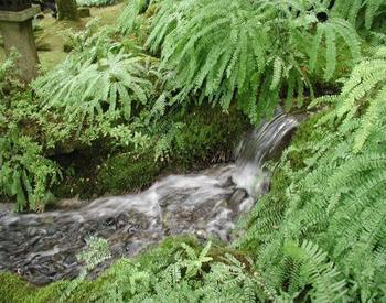
Riparian areas also benefit humans. Healthy riparian areas can maintain or improve water quality and have both recreational and economic benefits. As flooding or runoff occurs, riparian vegetation reduces water velocity, captures sediment and filters the nutrients and pollutants (pesticides, heavy metal, etc.) that would otherwise run into a water body (Figure 1). However, there is a limit to how much a system can manage before it becomes overloaded and degraded; care needs to be taken to maintain healthy riparian areas and beneficial land-use practices.
Stable, healthy and resilient riparian systems protect and enhance water bodies and surrounding environments for recreational activities like hiking, camping, hunting and fishing. These scenic qualities and benefits are enhanced by clean water and robust vegetation. In addition, there can be economic benefits from sustainably utilizing these or neighboring systems for agriculture or foraging purposes.
What are some threats to riparian systems?
Riparian systems are rich with biodiversity and are highly productive areas. Riparian vegetation in particular influences light penetration, soil health, water quality, air and water temperatures, and interactions between aquatic and terrestrial zones. It is therefore important to recognize threats to riparian systems in order to take management actions to mitigate damage and/or protect these areas. Some of the impacts that are important to be aware of include:
- Habitat loss.
- Invasive species.
- Pollution, and more.
Erosion
Erosion is a natural, biophysical process. Erosion rates differ from system to system and climate to climate. In healthy riparian systems, erosion does not significantly impact soil or riparian health. However, with improper management practices, the effects of erosion worsen and the system as a whole degrades. An example of this would be water erosion, defined as the removal of the top layer of soil, pollutants and nutrients by rainfall, runoff, irrigation and flooding. There are four primary types of water erosion (splash, sheet, rill, gully) that can seriously impact and degrade any ecosystem over time, especially riparian areas and agricultural land.
Climate change
Warming temperatures can alter natural conditions and put increasing stress on these diverse and delicate systems. Warmer climates alter snowpacks and hydrologic regimes (flooding, rainfall, etc.) that are necessary to maintain native vegetative communities and productivity of the region. Other concerns for riparian systems include the effects of converting to drier systems leading to an overall decrease in the resiliency of these systems. As the historic heat waves in June 2021 demonstrate, more attention is needed to better understand how to improve and maintain riparian and general ecosystem health in the face of rising temperatures.
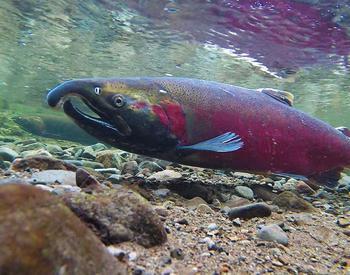
Increased air temperatures and altered hydrologic conditions can also lead to an increase in water temperatures and decreased water levels. Cold water is necessary for many riparian organisms, especially those cold-water salmonid species like salmon, trout and char that are important to this region. If these species don’t have proper cold-water environments (<16℃), their populations will decrease more quickly than current rates of decline.
With regard to wildfires, riparian systems can act as a buffer and disrupt the spread of fire if conditions are favorable. As summers continue to exhibit drier conditions, there is the potential for even more fuel accumulation or build-up that can leave riparian systems more vulnerable to catastrophic, high-severity fires. The build-up of dry plant material allows for wildfires to travel easily and quickly through ecosystems that may not be adapted to it. Fires are a natural and integral part of the landscape, but as temperatures increase, so does the frequency and severity of fires outside of natural ranges of variability.
On Oregon's north coast, where high-severity fires have historically occurred every 200-plus years, fires are now occurring at higher severities and broader extents than before. High-severity fires can have severe impacts on vegetation, thereby increasing the potential for erosion and sediment-loading into already disturbed water bodies. Some strategies to mitigate the impact of fire include removing fuel buildup around creeks, and planting fire- and heat-resilient plants in the riparian zone like willows (Salix), vine maples (Acer circinatum) and salal (Gaultheria shallon).
How can you tell a riparian system is degraded?
There are several different indicators of a degraded riparian zone. Degraded riparian systems will lose structure (physical characteristics) and function (operational characteristics). These important components are required for riparian systems to be healthy and provide those values of biodiversity, productivity, aesthetics and water quality. Some of the indicators of a degraded riparian zone that will be discussed include steep banks, lack of vegetation and invasive species.
Downcutting
Downcutting occurs when the water velocity of the stream or creek increases and causes the channel bottom to be eroded away (Figure 2). As a result, the water table drops, and the vegetation composition of the stream bank changes because water-loving plants will no longer receive the moisture that they need for survival. If appropriate management actions are not taken to mitigate stream incision, the channel will continue to incise and reduce the availability of water, resources, habitat and benefits for both humans and ecosystems.
Steep banks
Steep stream banks occur when the stream is shifting laterally. In Figure 3, the bank drops off steeply, weakening the overall strength of the stream bank and allowing for high rates of erosion and sediment deposition in the water. High rates of erosion and sediment deposition tend to decrease water quality and quantity as well as adversely affect salmonid redds if gravel on the channel bottom is covered with silt; salmon redds are depressions or “nests” created by female salmon on gravel stream bottoms to lay their eggs.
Steep banks often occur as a result of downcutting (Figure 2) and can result in bank sloughing. Bank sloughing, or bank failure, occurs when there is undercutting of the bank, bank seepage (which removes soil), or saturation of very loosely deposited material (which may occur from a lack of vegetation).
Vegetation loss and invasive takeover
Lack of vegetation in a riparian area can indicate a recent disturbance (fire, flooding, pathogens, etc.) that changed the conditions for successful plant growth. Disturbance is a natural phenomenon, but if extended can lead to the degradation of a system and leave it vulnerable to invasive takeover. Shallow-rooted vegetation may also be an indicator of degradation. Riparian vegetation needs deep, strong roots to stabilize stream banks against erosion and filter pollutants.
Invasive takeover refers to a system that has been overrun by invasive species and/or experienced poor management that led to changes in the structure and function (Figure 4). Systems that have been taken over will not be able to provide the same values to animal, aquatic or human populations. Common invasive species in north coast ecosystems include Armenian blackberry (Rubus armeniacus), Japanese knotweed (Reynoutria japonica), English ivy (Hendra helix), Scotch broom (Cytisus scoparius), gorse (Ulex europaeus), reed canary grass (Phalaris arundinacea) and more.
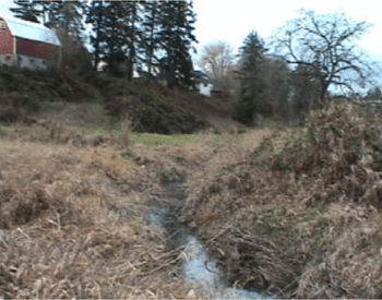
Channel straightening
Oftentimes, waterbodies are altered or converted (straightened, drained, etc.) from natural states to utilize the highly productive soils that are present for agriculture. However, these alterations can have drastic consequences for the ecosystem as a whole. When the meander (curvature) of creeks or streams is straightened, several changes happen. Those changes include a reduction of the length of the creek, an increase in the slope, an increase in water velocity, an increase in erosion, a decrease in habitat complexity, and an overall change of the structure and function of the system. If channels have been straightened, it is important to remember that the channel will not only incise but may also naturally regain its meander. Figure 5 shows how channel meanders shift naturally over time.