Transcript
[00:00:00] Andony Melathopoulos: It's no coincidence that all state managed pollinator protection plans have as their cornerstone communication between beekeepers, growers and pesticide applicators. When honeybee colonies are brought in for crop pollination. In fact, if you look at EPA guidance to the states on managed on creating managed pollinator protection plans, this communication step is right at the forum.
[00:00:27] Now during a busy pollination season, it's oftentimes difficult to stay on top of everything and make sure that communication happens. And that's where my guests this week comes in. Bob Walters is the director of business development at field watch, and many states around the United States have this platform this online and phone app platform called iCheck that allows growers.
[00:00:52] To check the landscape around their area before they apply a pesticide application. And if they don't know that there's a bee colony in that area, or be callings in that area, it pops up with a kind of notification so that it facilitates that communication before pesticide applicants applications take place.
[00:01:09] So this week we're going to learn about bee check and field watch with Bob Walters on policy.
[00:01:21] Bob Walters: Welcome to the pollination, Bob. Good
[00:01:24] Andony Melathopoulos: morning. Good morning. And I guess to begin with we're going to be talking about pesticide drift and bees, and I guess for many people, what is pesticide drift and why does it happen?
[00:01:36] Bob Walters: Yeah, that's a really good question that people fundamentally probably know, but they may not really know.
[00:01:42] Pesticide drift and the simplest form is the off target movement of chemicals. It happens anytime you spray a agriculture field, you spray plants, you spray golf courses, you spray along roadsides. There's the potential for that chemical moving to a target that it wasn't intended for. That is the key reason and the key driver for why we originally developed our.
[00:02:08] Andony Melathopoulos: So I get I get this. So it's like an ideal world, every drop of herbicide, every drop of fungicide, every drop of insecticide would go right to where it needs to go. But there's always some that just doesn't miss misses the target and moves somewhere where it's not supposed to go. And I guess that can have, negative impacts if it's, a sensitive area or.
[00:02:30] And what w what kind of things do pesticides drift onto that can be a real problem. I guess it's a, you guys deal with this a lot.
[00:02:36] Bob Walters: We deal with this every day. So pesticide drift can happen when, because of wind it can happen because of the heat. It could happen because of just the weather condition.
[00:02:47] That the spray that was intended for a roadside or for weeds in a field or some type of test in a field, may move to another field that it wasn't intended for. So we can happen fairly easily. And the person spraying is always responsible to be aware of what they're spraying, what they're spraying on, what type of chemical they're spraying and what is potentially nearby or downwind from where there's.
[00:03:16] Andony Melathopoulos: Yeah, I suppose it could be something like your, you have a neighbor who has an organic farm and that would just, disqualify their crop or imagine w here in Oregon, sometimes you hear about herbicide drift and wine grapes where, it can cause a lot of damage to the wine grapes if they're intended for a RAs field.
[00:03:32] But imagine there's all sorts of situations that people don't think, almost hard to think about all the contingencies, but some once in a while, these things can move off target and have these impacts.
[00:03:42] Bob Walters: Yes, that's absolutely correct. In fact, grapes and organic crops are two of the crops that are most identified on our maps because they are highly sensitive to chemicals that they want, that were intended for them intended for something else.
[00:04:00] And the damage to those crops is significant, not just financially, but operationally. And it affects the person. That is growing those crops or is expecting to have a yield on them as well as the person sprang. Sometimes they're going to be affected too. So I could be a financial application, could be it'd be in the news too.
[00:04:22] So those crops are highly sensitive and certainly an awareness needs to be
[00:04:29] Andony Melathopoulos: done. Tell it so that DriftWatch was developed as a tool to say. Make people more aware of these situations and where these sensitive areas are. Tell us how DriftWatch works. What's the, in its first origins in dealing with this problem of off target drift and outside of bees, how has it most frequently used it?
[00:04:48] We've talked about organic crops and grapes and things like that, but tell us a little bit more.
[00:04:52] Bob Walters: Yeah, absolutely. So DriftWatch with was developed at Purdue university over 10 years ago. By the Purdue agriculture engineering and biological engineering department. It's primary use at that time was to be used by tomato growers in central Indiana, Southern Michigan, Western Ohio.
[00:05:13] A significant number of tomatoes are grown in that area. There's a large private processor in the essential Indiana area that processes tomatoes and tomatoes happen to be one of the crops. Highly sensitive to chemicals. And so what happened? They developed this mapping tool using Google maps to be able to identify where the tomatoes are because over a period of a few years, 2, 3, 4 years there was significant loss of cross into hundreds of thousands of dollars for several years.
[00:05:49] So the company red gold went to Purdue and they developed this. So they could identify where their crops are going to be grown each year. The spray drift that was coming, being sprayed on corn and soybeans, it wasn't an intentional thing. It was just because they didn't know there were tomatoes close by or downwind or adjacent because last year they were not bad.
[00:06:11] As a lot of vegetable crops, they rotate or fields. The tool was developed to be able to communicate those crops. Then we had other crops that got other crops, growers got interested. They were growing specialty crops, tomatoes as a group of specialty crops. There's 40 some identified specialty crops in the United States, grapes, orchards, other vegetable, they got identified.
[00:06:38] The registry as we call it the mapping registry, where the grower would voluntarily map their special crops grew really fast, really quick. I grew outside of Indiana included three other states early on outside of Indiana. Got the Illinois. Wisconsin and Michigan. And then as we were developing the tool it was definitely very important to us to identify other things that would be sensitive to spray.
[00:07:06] And bees was one of the number, one things, if not the number one outside of crops, early on bees who were identified as just another crop in the dropdown as time went on. We've modified our mapping tool to allow bees to be math a little bit different because they're not a crop and there's some different needs by beekeepers.
[00:07:28] So since then the tool has grown significantly. The tool DriftWatch is still the name of it today, but the university decided roughly 10 year ago, years ago to move the two registry outside of the university create a company. Called field, watch that manages and operates the registry on a daily basis.
[00:07:51] And so now field watch manages the DriftWatch specialty crop registry as well as three other registries, one for beekeeper. One for row crop growers that will grow non-GMO or other sensitive crops that may be grown in row crop areas. And then most recently we've developed in our managing a registry that identifies where workers are and fields so that somebody that's spraying chemical on a nearby field would know that there's workers there primarily using the Midwest or the task slurs and other workers in Seaport.
[00:08:29] So we've got four registries today. The common theme amongst all of them is communication. Communicating to somebody that's spraying a chemical, what may be nearby downwind or adjacent to where they're at today.
[00:08:43] Andony Melathopoulos: And I guess that's where I can quickly see the connection to beekeepers.
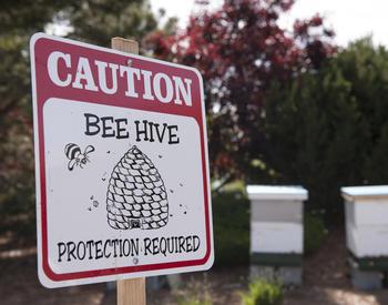
[00:08:47] We know, I think I'm previous episodes. We've talked about managed pollinator protection plans. All of the states. Have these plans, including Oregon and really key in those plans is the area of communication and communication or communication to happen. You need to, know where the bee colonies are.
[00:09:06] So can you just walk us through, so you're a beekeeper, you've got your colonies, I imagine California is a great example. We're talking about California because it's, this is where I think a lot of Oregon beekeepers will encounter this. They place their colonies at a number of orchards.
[00:09:24] How does the, how do growers, both the grower that's renting the colony, but I imagine growers adjacent who, their bees are going to be visit. How did they use this tool and how does this whole all work? How does a beekeeper put their colonies down and mark them and walk us through?
[00:09:39] Bob Walters: Yeah.
[00:09:40] So beekeepers obviously have faced several challenges with their bees. Pesticide drift is just one of them. There's obviously other issues they face, but in this issue, this is one that probably can be managed and addressed more so than maybe other than some of the other issues they face. So how it works, it's fairly simple.
[00:10:00] Beekeepers will identify their location. We have a mapping tool that you can use a desktop browser version for. And after you have an account set up, you just go based on your GPS location and put your DS on that map. That information, and specifically in California has been sent right to the county ag commissioner who managed that data and other states, then information goes on a public map so that somebody that's spraying would know there's these.
[00:10:32] One of the unique things with these is that we know that there are different types of beekeepers, hobbyist, and commercial ones, and we encourage all of them to map their hives because all bees really are important to several things, not just for production of honey, but pollination as well as overall agricultural production.
[00:10:52] So they are critical part of the process. And as we continue to. I have more and more bees, more and more pollination and agriculture demands. It's important that least in this way, they can be identified and potentially protected from chemicals that are being drifted because oftentimes, beekeepers are concerned.
[00:11:14] About a lot of things. And with pesticide drift, if somebody is aware that they're there, that is a helpful communication method. So they have their choice. The tool is voluntary. They don't have to use it. But in some states the use of it is significant because people are very concerned about their bees and want to make sure that, that somebody is spraying knows that they are.
[00:11:35] Andony Melathopoulos: I suppose in some states there is a good structure put in place by the state department of agriculture, either making it mandatory to register, or, I'm curious about the case in California, how that works. But so there's various levels of how states adopt the bee watch program.
[00:11:53] But for Oregon, I think what would be great is to hear a little bit more about how it's used in California, because that I think is. As we don't have watch in Oregon, most of our beekeepers are going to encounter it when they get into California. Tell us a little bit about how that how that works, how the communication chain works there.
[00:12:09] Bob Walters: Yeah. So you are correct in most of the states that we operate in 23 states today beekeepers map their hives, and then they. Identified and approved by somebody at the state level to go on to the map. Some states, Iowa, North Carolina, a few other ones, actually never registry that the beekeepers need to sign up for so that the state can communicate to them.
[00:12:33] If there's some type of virus or other issue they're trying to address, or some, something that is potentially dangerous to the beehive in California, the situation was a little bit. Because of the way that they've processed and do chemical applications, it's all gone through an online application, which is controlled at the county level.
[00:12:54] So the bees in California are not on a public map that is controlled at the county level so that not everybody can see them. And an applicator can only see. What is nearby or Jason or downwind from what they're going to spray. And there's a significant amount of spring that goes on in the valley, California with the bees.
[00:13:15] So they submitted a request it's reviewed by the county ag commissioner. They provide back electronically. Everything's done online. They provide back electronically to locations of beehives near where the. Right prior to digitizing this all the beehive locations in California were kept on a map with a little pin until he had these pins all over this map and we'd have to move them around when they would move.
[00:13:44] So now it's highly streamlined now, because now it's all online. The beekeeper can go on and move their hives. They move them when they bring them into the state for pollination. Thousands and thousands of beehives brought in, they register them, put them on the map. There are a lot of beekeepers that are resident of California, so their stay on there, but California is a unique situation.
[00:14:07] But now we probably had hundreds of thousands of beehive locations all over the state. The number increases significantly. Over the next few months because of the bees being moved in for overwintering and then for pollination in the spring of the helmets. The tool makes it very simple because in California, you are also required to register your bees.
[00:14:28] So this makes it so simple for a beekeeper to do that. They're moving them in from all over the United States. But then they are then identified and that information is communicating, which is consistent with our communication thing and all the other space we have.
[00:14:41] Andony Melathopoulos: And that must be the most integrated system where, a grower needs to, has got to put their, they're going to do a spray.
[00:14:46] They have to, indicate it, the beekeepers there. And it if, there's a lot of data around so that the communicate that facilitates the communication. I imagine in other states where it's voluntary, it really does require a good educational push to let growers know before they spray or aerial applicators or vector control districts.
[00:15:06] Check this map before you go out, because not only will you see if there's organic props around, but you'll see where the bees are. And those are sensitive. Tell us a little bit about how that's worked and what are some good, best practices for making this technology work in.
[00:15:22] Bob Walters: Yeah. So the at the end of the day, the applicator is responsible and the label is the law for them. So they're spraying a chemical that identifies itself as being potentially risky to bees. They need to be aware of the beehive vocations. There are labels that dictate that they have to check a registry and make sure they're aware of it.
[00:15:43] What happens on a daily basis, multiple times a day, applicators were checked the registry, some of the applicators actually get the data streamlined right stream, right to their mapping platform that they use, or their logistics platform work order platform that they use in their trucks or in their plane.
[00:16:03] And so they know the locations prior to, and so they subscribed to getting that data that helps them. In terms of just knowing where they're at, how far are they aware way from something that they're going to spray every single day, we get feedback from beekeepers that say, Hey, that the applicator just called me.
[00:16:24] They're going to spray next Tuesday. They want to know what would be a good time to spray. And that's the communication that goes on between the beekeeper and the app. And beekeepers as they are, they really understand their bees. They know them, they manage them. They know when their bees leave the hive, they know when they come back.
[00:16:43] So a beekeeper then has the opportunity to either close up their hives or indicate to the applicator. If he sprayed early in the morning before. It works out well because my bees have left. So it's a give and take the applicators certainly need to spray whether they're spraying agriculture land or they're spraying for mosquitoes or they're spraying along the roadsides.
[00:17:07] They certainly know where the bees are if they communicate with the beekeeper and they work together. So the success of the program really has been by the feedback from those stories, as well as just the sheer growth. The number of beehives that are being added every single year and locations across the United States is just significant.
[00:17:28] And it certainly has helped the communication as well as it helps the bees maintain themselves over the, to the point that they continue to do what they need to do. And the applicator can do what they want to do.
[00:17:39] Andony Melathopoulos: It really does strike at the heart of the managed pollinator protection plans of communication of working things out on the ground.
[00:17:47] The give and take is I've got calling the beekeeper up and saying I've got a legal problem and here are my chemical choices and here's what your options are. And if I don't, I'm going to have damage. I'm always impressed by beekeepers and growers. When they're able to talk to one another before an application goes on how, they can work through problems, pretty effective.
[00:18:07] And I guess the thing, one thing I've, we've I've heard is that one concern that beekeepers have, and I think it's addressed, and maybe this will get into the question of how changes have taken place in the platform over the years is beekeepers worried. They're like if I don't want other beekeepers to know where my callings are, I don't want the public like come and vandalize my colonies.
[00:18:26] How does how's the platform dealt with those issues over the years and what are some of the other changes that have taken place over the.
[00:18:33] Bob Walters: Yeah, that's a great question. And in fact I'm often surprised when that question doesn't come up because it's so relevant to the beekeeper. We'll be keeping them history in terms of awareness and that using technology in today's world, the concern for their bees.
[00:18:49] So early on when we had DriftWatch, bees were treated as another crop, we quickly learn that. They need to be identified differently. So we developed a registry beat check which is a parallel or a sister registry to drink watch. So a beekeeper would start there. All the data that is in our system goes to one repository.
[00:19:15] It doesn't matter if it's a great board grapes. It doesn't matter if it's BS or some type of sensitive world. They all go to the same wrenching for applicators to see for beekeepers. We developed this registry because there were concerns about being on a public map. They were concerned that location, they had multiple highs versus just one.
[00:19:36] Now they were concerned that they were going to, they needed to move their highs at different points times. So when we developed the beach check register, We built those capabilities in there and which you're not really that important for specialty crops. Cause they're not moving things. They don't need to identify themselves commercial or hobbyists.
[00:19:55] So a beekeeper could put in the number highs from one to whatever in there they can mark their locations as private and that prevents them from being on the public map. So an applicant would have to be registered with us and have an account and log in. To be able to see those beehive locations. So we have thousands and thousands of applicators registered with us across the United States and they will register and sign in to see those locations.
[00:20:26] And if they don't, they wouldn't see the ones that are marked private, that really helps address that concern potential of vandalism or theft of beehives. I'm not saying it's the answer for everything, but it helps significant keep beekeepers comfortable that there was a way for them to still put their hives on the map so that applicators would know where they're at, but then not have all the public know where they're at.
[00:20:53] When, after we did that, we realized we even had to improve on that. So we developed an app that could be used on. Different types of devices that beekeepers can use. They're an app. So they don't have to be in front of a computer. They can be in the field of where they're at, as long as they have access to a GPS location.
[00:21:13] So that app has been developed to make it easier for beekeepers to map or move or change your hives. There, they can put a date in there when their beads are going to be present, and then they can put a date in there when they're gonna move them. The important thing is that data comes on or off the map based on the dates that they put in there, the information they put in there whether or not they have a hobbyist or commercial providers.
[00:21:37] So we've even made it so simple that if a beekeeper has multiple locations, multiple, whether it's 10, 20, 30 locations and they have them all in a file, we can upload them easily for them. So they'll have to sit and do all those. So we've built some technology to make it simpler for them.
[00:21:55] The beekeeper feedback has been phenomenal. We know that not every beekeeper wants to use it or is concerned about it, but we fully believe based on the growth of the number of hives that we've had over the last several years, double digit growth each year, that that's an affirmation that something's going well, and people do like to use the tool and we can.
[00:22:17] Hundreds of thousands of beehives moved every year to for a variety of reasons, mostly for pollination. So all in all the technology continues to improve. We continue to do things to make it relevant and really believe that by incorporating this tool as a communication method for MP3s, then it really helps tie it all together.
[00:22:40] In terms of communicating, be a really a good practice for beekeepers, a good practice for applicators to use so that they can work together to help identify beehives and really at the end of the day, prevent any type of issue or spray drip onto bees, because that's really what, we're, what we're working on.
[00:23:02] After the fact it's too late, but this is really to prevent something. And so that both parts. Don't have an issue, whether you lose bees or when you spray something and you caused an issue, there's a commercial value there to the bees. We firmly believe that this is really has helped the beekeeping industry and it has been well adopted.
[00:23:21] Andony Melathopoulos: Bob, maybe just a wrap up. Can you maybe tell us a few success stories, stories that you've heard over the years that really exemplify. How the, how this tool really not only foster, generates a conversation between applicators and beekeepers, but also leads to productive solutions.
[00:23:39] Bob Walters: Yeah. So what the problems access stories really have to do with a pollinator protection plans would that came out several years ago. All those dates that I started developing looked at ways that they could communicate. The applicators that are spraying pesticides and they identified field watch. And then specifically our beach check registry as the tool to use, we are even referenced in some of the space we're not operating in yet as the communication tool.
[00:24:09] So we, we think that as a positive. Another thing, I think that a success story just recently, we started mapping all the beats and there's four or 500 locations in Washington, DC. Our nation's Capitol now in the nation's Capitol. There's very little, if any agriculture it's all urban or suburban areas and the beekeepers there are concerned.
[00:24:35] About suffering that goes on to lawn trees, shrubs, golf courses, spraying for mosquitoes in the urban area, which happens quite a lot on the east coast. So we say that a very huge success for story we've always had urban beekeepers map their hives for a variety reasons, but this has really has been a significant star for us to really reinforce the importance of beekeeping.
[00:24:59] No matter if it's an agriculture and urban or suburban area. And they all need to be identified so that somebody that spring chemical, because the people that are spraying out there and BC are not residents to DC, they're coming from Virginia or Maryland, potentially Delaware they're coming from someplace else.
[00:25:18] So what we do know is that applicators that they travel across state lines and city line and county lines. This helps them as a, as being a tool that could be. Across cities across state lines so that they know where sensitive crops are, beehives are so that they can be a good steward. We're really promoting the use of the tool as a stewardship tool really helps with communication and collaboration between their respective groups.
[00:25:49] So I would say that those success stories are what we continue to build on.
[00:25:54] Andony Melathopoulos: That's fantastic. It does raise this whole issue of new uses popping up people figuring out when you have the tool, just figuring out how to, how did make, conversations and pulling and protection on the ground.
[00:26:05] And I really liked. Yeah, I happen. And I really liked the idea that an applicator traveling to new area doesn't know the landscape. Hasn't had the conversations with the local beekeepers, all of this is new. And so knowing that they can come in, as I'm thinking about aerial applicators as well, who are in demand and very skilled and talented coming into an area knowing they can pick up there.
[00:26:26] No where the colonies are and just plan their day accordingly. That must be just a great tool. And I'm really excited to have you on the show today. Today I'm glad to bring to our listeners this technology, and it seems like it's going to be a great tool moving into the future as it develops for protecting the country's honeybee colonies.
[00:26:43] Bob Walters: Thank you very much.
A key principle of state Managed Pollinator Protection plans is to increase communication between beekeepers and pesticide applicators during crop pollination. In this episode, we hear about an initiative to map bee colonies to help applicators find bee colonies in the landscape to help facilitate beekeeper-applicator communication.
Bob Walters is responsible for the technology operations, development of new business relationships with states, members, and software partners. FieldWatch operates the DriftWatch Specialty Crop Site, BeeCheck Apiary, and CropCheck registries to increase stewardship and collaboration.
Links Mentioned: Bee Check