The wildland urban interface
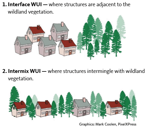
The U.S. Forest Service defines the wildland urban interface, or WUI, as any area where “humans and their development meet or intermix with wildland fuel.” Communities that are within a half-mile of this mix are included. The WUI is split into two categories:
1. Interface WUI — where structures are adjacent to the wildland vegetation.
2. Intermix WUI — where structures intermingle with wildland vegetation.
The WUI is where wildfire impacts have become most pronounced and most costly, especially over the last six years — the hottest years recorded on Earth over the last 140 years.
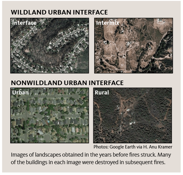
But there is an increasing trend of homes and buildings being destroyed in urban areas from wildfires — not just in the WUI. For example, 25% of homes (almost 3,000) lost in the Tubbs Fire around Santa Rosa, California, (total cost $1.3 billion in damages from the fire) were in an urban setting and not in a WUI. An urban area, or “built-up area,” is a human settlement with a high population density and an infrastructure of a predominantly “built” environment. Though structures are burned in greater numbers in the urban environment, these areas are not included in the current definition of WUI.
This is a new and disturbing trend that needs to be addressed. We need new fire behavior models that incorporate structures for a better understanding of how to prevent and manage these fires. We need a set of structure fuel models to drive a new National Fire Danger Rating System for the built environment.
The wildland urban interface in the 48 contiguous United States has grown rapidly over the past couple of decades, making it the fastest-growing land-use type. More than 60% of new homes in California, Oregon and Washington are built in the WUI.
Structures as fuel
Many fire risk reduction plans focus on reducing flammable vegetation to mitigate risk. In the WUI (and now outside the WUI in urban areas), where so much of the destruction is taking place, we have to consider fuel types other than vegetation. We now need to consider structures themselves as a fuel type contributing to wildfires, along with other potentially hazardous fuel such as wood piles, propane tanks and automobiles. In this context, the home defense (ignition) zone and all the needed mitigation strategies take on a heightened importance and urgency.
Defensible space within the “home ignition zone” is defined as the area around a structure where the landscape is designed and maintained to decrease fire danger. Creating defensible space also gives firefighters a chance to safely protect your home.
Individual homes today burn faster than they did 50 years ago. Now, when a fire starts in a room, it can transition to “flashover” (when a fire in a room becomes an entire room on fire) in approximately three minutes, compared to 30 minutes in homes several decades ago that contained natural furnishings and building materials. This is due to several factors:
- The replacement of natural with synthetic materials in home contents and construction.
- An increase in square footage in modern buildings.
- More open floor plan designs that are less compartmentalized.
- A transition to lightweight construction materials and building methods.
These factors contribute to more homes being destroyed by wildfire, especially in urban areas when one house may ignite very close to the next one. Flames, embers and radiant heat can ignite adjacent structures in a domino effect. The domino effect becomes worse when more homes are built closer together. Adding to this complexity are red flag weather conditions such as hot, dry winds, low humidity and high temperatures. Red flag conditions drive the intensity and severity of fire behavior. For these reasons, more homes are at risk today than in wildfires years ago.
Responsibility
The relative risk of any hazard (such as power tools, ladders, vehicles and fire) is measured by the probability of it causing harm to something of value (such as your home, your resources or your life) — and to the potential degree of harm that may result. Responsibility for identifying and assessing potential hazards and mitigating the relative fire risk begins with the homeowner or resident.
Contact your local fire professionals for help to assess your home and property’s relative fire risk and to discuss priorities and ways to lower that risk by reducing or mitigating the hazards. For example, you can mitigate risk by:
- Creating a safe and defensible space within a home by having fire extinguishers and smoke alarms.
- Creating defensible space surrounding your home by cleaning gutters, pruning and mowing.
- Reducing fuels throughout your property and adjacent properties by creating a defensible zone surrounding (and throughout) your home and property.
- Creating safe and accessible entrances, exits, evacuation routes and water sources.
These are all mitigation measures that you can control and implement to reduce risk.
It’s also important to engage with neighbors to initiate and develop neighborhood plans or landscape management plans to assess risk and identify mitigation projects. Fire does not respect boundaries. The National Fire Protection Association’s Firewise USA program provides steps to mitigate and reduce risk within a surrounding property and throughout a neighborhood.
Being proactive and identifying a hazard’s fire risk and then mitigating that risk will go a long way to reduce the impact wildfire can have on your home and property — and your community.
Structures are fuel — boxes of fuel containing items of fuel that will burn when ignited. Fire risk can be lessened when homeowners take measures to identify, assess and reduce hazards inside the home, within the surrounding property and throughout the neighborhood.
References and resources
Bennett, M. and C. Nichols. 2020. The Home Ignition Zone: Protecting Your Property from Wildfire. EM 9247. Oregon State University Extension Service.
Leavell, D.M. 2015. Fire Adapted Communities: The Next Step in Wildfire Preparedness in Klamath County. EM 9116.
Bennett, M., S.A. Fitzgerald, A. Jones and K. Baylog. 2017. Keeping Your Home and Property Safe from Wildfire: A Defensible Space and Fuel Reduction Guide for Homeowners and Landowners. EM 9184, Oregon State University Extension Service.
Kerber, S. 2012. “Analysis of changing residential fire dynamics and its implications on firefighter operational timeframes.” Fire Technology 48(4):865–891
Kramer, H.A., M.H. Mockrin, P.M. Alexandre and V.C. Radeloff. 2019. “High wildfire damage in interface communities in California.” International Journal of Wildland Fire 28(9):641
Leavell, D.M., C. Berger, S. Fitzgerald and B. Parker. 2017. Fire Science Core Curriculum, module 5 (Fire Prevention for Home and Landscape), EM 9172. Oregon State University Extension Service.
Leavell, D.M., A. Markus, C. Bienz, K. Carlsen, E.J. Davis, M. Douglas, D.F. Ferguson, L. Fledderjohann, K. Johnson, N. Livingston, J. Pettigrew, G. Rogers, M. Schreder, D. Shoun and L.A. Vradenburg. 2018. Planning and Implementing Cross-boundary, Landscape-scale Restoration and Wildfire Risk Reduction Projects: A Guide to Achieving the Goals of the National Cohesive Wildland Fire Management Strategy. PNW 707. Oregon State University, University of Idaho and Washington State University.
National Fire Protection Association’s Firewise USA Program
Radeloff, V.C., D.P. Helmers, H.A. Kramer, M.H. Mockrin, P.M. Alexandre, A. Bar-Massada, V. Butsic, T.J. Hawbaker, S. Martinuzzi, A.D. Syphard and S.I. Stewart. 2018. “Rapid growth of the U.S. wildland-urban interface raises wildfire risk.” Proceedings of the National Academy of Sciences 115(13):3314–3319
Stewart, S.I., V.C. Radeloff, R.B. Hammer and T.J. Hawbaker. 2007. “Defining the wildland-urban interface.” Journal of Forestry 105:201–207
USDA Forest Service report. 2019. “Most California wildfire is in wildland-urban interface area with less fuel, more people.” U.S. Forest Service — Northern Research Station.
© 2020 Oregon State University.
Extension work is a cooperative program of Oregon State University, the U.S. Department of Agriculture, and Oregon counties. Oregon State University Extension Service offers educational programs, activities, and materials without discrimination on the basis of race, color, national origin, religion, sex, gender identity (including gender expression), sexual orientation, disability, age, marital status, familial/parental status, income derived from a public assistance program, political beliefs, genetic information, veteran’s status, reprisal or retaliation for prior civil rights activity. (Not all prohibited bases apply to all programs.) Oregon State University Extension Service is an AA/EOE/Veterans/Disabled.
About the authors