Think of a water-quality swale as a rain garden in motion: It treats runoff while simultaneously moving it from one place to another.
Water-quality swales (WQ swales) are linear, vegetated, channeled depressions in the landscape that convey and treat runoff from a variety of surfaces. Runoff may be piped or channeled, or it may flow overland to a swale. As water passes through the swale, some runoff may infiltrate, or seep, into the soil.
Not all swales are WQ swales. Conveyance swales, such as ditches, move water from one place to another. But these are likely narrow channels with no vegetation and little to no water-quality benefits. WQ swales may be planted either with grass or landscape plants, although most Oregon jurisdictions have moved away from grass. Design elements may vary in several aspects, including function, vegetation type, and physical setting.
The terms “rain garden” and “swale” are often used interchangeably, but rain gardens hold runoff and treat it, while swales treat runoff as it is conveyed. Depending on the design, the resulting water-quality benefits can differ greatly, but water-quality swales generally provide lower benefit than rain gardens or stormwater planters.
Site conditions
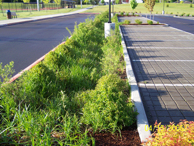
The channel and linear design of swales make them suitable for roadside runoff capture, although residential areas with frequent, closely spaced driveway culverts may not be ideal locations (Barr 2001). You may see swales in front and back yards, along parking lots, and beneath roof spouts (Barr 2001). Swales can also serve as substitutes for curbs or gutters. Siting a swale on stable soils can also prevent erosion (Field 2007).
There are two kinds of WQ swales:
- Infiltration swales allow some runoff to permeate into soil as it conveyed.
- Filtration, or lined, WQ swales are lined with an impermeable material that does not allow water to soak deep into the soil profile, and ultimately all water is conveyed through the filtration swale.
Both infiltration and filtration swales have been used successfully on private property, public property, and within the public right-of-way. Swales can be built in both new and existing developments. Although they are generally designed for smaller areas, swales can be constructed to help manage the appropriate volume of runoff in larger areas.
Infiltration vs. filtration swales
Infiltration swales can be used in locations where:
- The seasonal high groundwater table is lower than 24 inches from the bottom of the swale;
- The bedrock is lower than 18 inches from the bottom of the swale;
- They are at least 5 feet from underground utilities;
- Buildings are at least 10 feet away;
- They are directly adjacent to pier footings;
- They are at least 100 feet away from down-gradient slopes of 10 percent. Add 5 feet of setback for each additional percent up to 30 percent, and avoid installing a WQ swale where the down-gradient slope exceeds 30 percent.
- They are designated by a qualified licensed engineer or geologist who has signed and stamped a geotechnical report, site plan, or letter.
Filtration, or lined, swales should be used instead of infiltration swales:
- Where the seasonal high groundwater table is higher than 24 inches from the bottom of the swale;
- Where the bedrock is higher than 18 inches from the bottom of the swale;
- In contaminated soils and groundwater;
- In potential stormwater hotspots (vehicle fueling areas, industrial loading, unloading, and material storage areas);
- On slopes exceeding 10 percent, and in landslide areas;
- Over karst bedrock; or
- Where adequate setbacks cannot be met.
Removing pollutants
Generally, swales are good at removing small particles of pollutants and less effective when it comes to slowing or storing runoff (NCDWQ 2007). However, the addition of check dams that hold runoff will turn the swale lengths into small rain gardens with an improved capacity to treat and infiltrate. (See Rain Gardens, EM 9207.) The shape of the bottom of the facility will also determine its effectiveness: A flatter and wider facility will lower the flows, resulting in greater opportunity for treatment. Methods of pollutant removal include settling out sediments, infiltration through soils and media, and biological uptake through plants.
Based on published research, the Center for Watershed Protection estimates that the event mean concentration phosphorus-removal rate is 20 to 40 percent, and nitrogen removal rate is 25 to 35 percent. Runoff reduction was estimated at a conservative 0 percent because few documented studies provide this information. However, if check dams are used or infiltration is intentionally incorporated into the design, runoff can be reduced (CWP 2008).
In general, studies have shown lower removal rates for grassy swales (such as those in a mowed lawn) than for vegetated, unmowed swales. Consider grassy swales for low-sediment-loading applications, such in residential lawns. Grassy swales can easily be mistaken for a place to recreate or walk the dog; educational signage might help to reduce the pollutants generated directly in the facility (EPA 2006). The Center for Watershed Protection estimated event mean concentration phosphorus removal rates for grassy swales at 15 percent, and nitrogen removal rates at 20 percent (CWP 2008).
Cost
Costs include permitting, construction, and maintenance. Many swales are used as replacements for curbs and gutters and are generally more cost-effective than piping, although they do occupy larger areas. Ongoing maintenance costs are similar to other vegetated areas and relatively low compared to other facilities.
Maintaining a grassy swale is typically more expensive than maintaining a vegetated swale, where plants are chosen to match the site characteristics and require minimal pruning and inputs. It costs more to remove sediments from swales and repair erosion due to their shape and access difficulties; be careful to prevent damage of inlets, outlets and side slopes in all phases of the project (Arnold 1993).
Design
Variations in design can increase the efficiency of swales, either in the conveyance of runoff or in the quality of water (Field 2007). In general, the faster water flows through the facility, the less effective the water quality treatment will be.
Stormwater managers set standards for system capacity by measuring the intensity of precipitation over a period of time. A “design” storm is a theoretical storm that facilities such as swales are designed to treat. The size of the storm is analyzed to occur at a given frequency. They are described as 6-month, 1-year, 2-year, 25-year, or 100-year storms that occur over a 6-hour or 24-hour period. The size and duration of the design storm is typically specified by local regulations. Each storm generates a peak flow, which is the fastest rate of flow leaving the drainage area coinciding with most intense portion of the design storm.
Unlike rain gardens, which are modeled as ponds, swales without check dams are conveyance systems, or reaches, and should capture and treat the volume of the water-quality storm for your region. Clean Water Services in Washington County has required water-quality swales for many years and has some excellent guidance on the hydraulic and hydrologic modeling available on its website (CWS 2007a).
The ability of a low-impact development facility such as a WQ swale to treat a given design storm should match the ability of its “gray infrastructure” cousin, a pipe. Pipes in Oregon are usually required to convey either the 10-year or the 25-year design storm. WQ swales slow flows by design, and infiltration swales also allow water to soak into native soils, thus requiring a smaller footprint.
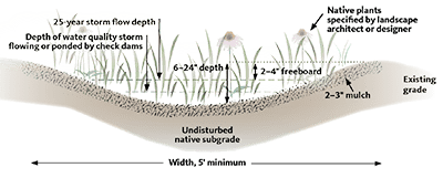
Freeboard (the depth from the maximum flow depth to the top of the facility) for these facilities varies by jurisdiction, and can vary on a case-by-case basis, depending on the safety or hazards of an overflow event. A freeboard of 6 inches should be provided for a facility designed to handle a 10-year storm (Field 2007, Barr 2001). Check your local planning department for specific design requirements for your area.
Sizing
Dimensions for a water-quality conveyance swale are calculated in relation to the volume of water treated and conveyed (BES 2016). Flow velocities through swales depend on the slopes and area of the basin contributing runoff. Flow depths should not exceed
6 inches; studies have shown that flows over this depth through vegetation do not receive adequate water-quality treatment (CWS 2007a). Runoff flowing over and out of the swale should be retained a minimum of nine minutes to adequately treat water.
The facility should drain the runoff volume in the filter soil within 24 to 30 hours, via flow out the bottom of the swale, infiltration into native soils, or via an underdrain (Barr 2001). If underdrains with perforated pipes are incorporated into an unlined infiltration design, refer to underground injection control (UIC) regulations, page 7.
Dimensions
A swale with a trapezoidal cross-sectional shape is the easiest to maintain, causes the least scouring, and creates the least runoff (NCDWQ 2007, Field 2007). This shape is the most difficult to build, however, because soil does not tend to conform to hard angles. In a wider facility, runoff will have contact with greater surface area, removing more pollutants (Field 2007, NCDWQ 2007). Other shapes include parabolic, which is acceptable if the width is equal to a trapezoidal design (Field 2007), and triangular or v-shaped, which are acceptable curb replacements in low-density areas (NCDWQ 2007).
A minimum length of 100 feet is suggested for WQ conveyance swales located in low-density areas where they are often used in place of curbs. However, setting a 100-foot minimum makes sense only if swale dimensions and planting density (channel roughness) are specified. Bottom widths range from 2 to 8 feet; wider facilities improve the water-quality treatment capacity of the swale (NCDWQ 2007).
The initial depth of a swale is impacted by the method of conveyance to it. For example, if the swale receives either overland flow or concentrated flow from lateral flow through an open-ended trench drain, it will be shallower than a swale that has runoff piped to it, since pipes need a minimum of 12 inches of cover. A number of jurisdictions require a freeboard of 6 to 12 inches, and this requirement can affect the depth of the facility.
Slopes
Side slopes for the facility should be constructed at a ratio of 3 feet horizontal to 1 foot vertical, or less; this is often seen written as 3:1 (Field 2007). Flatter slopes provide greater surface area contact for the runoff, thereby increasing pollutant removal levels (NCDWQ 2007). Slopes steeper than 3:1 must be compacted during placement, which makes it harder for plants to grow and thrive.
Ensure that the slope of the swale is not so steep that runoff causes erosion as it flows from inlet to outlet, taking into consideration the other parameters used to calculate flow velocity, such as channel roughness and swale shape.
Check dams
Check dams slow flows by allowing water to back up behind them before overflowing into the next length of the swale, often called “treatment cells.” They can be constructed of stone or untreated logs (never use treated wood) and are generally 3 to 6 inches high (NCDWQ 2007). Earthen check dams are not recommended because of the potential for erosion (Field 2007), although vegetated dams have been used successfully. Portland has successfully used check dams made of large pieces of crushed rock (the same material used for riprap) in a number of its public facilities.
Check dams can be used to slow velocities and ensure that water flows down into the soil and not out of the outlet too quickly. Use a check dam to prevent erosion when a swale has a slope of greater than 5 percent (Barr 2001, NCDWQ 2007).
For facilities with check dams, use a ponding depth of 12 inches to keep plants healthy. When check dams are added to a WQ swale, the facility functions like a series of linear, cascading rain gardens, sometimes referred to as a a low-impact development (LID) swale. See Rain Gardens, EM 9207.
Energy dissipaters
Runoff at inlets can erode soil, especially when concentrated to enter the swale at a particular place. Create a rough surface to slow flows; use baffles, forebays, or even modified catch basins. Smooth, concrete channels are not recommended unless designed to tip back towards the inlet; these channels will simply transfer erosive flows from the entrance to the end of the channel.
Riprap is placed at the entrance of many facilities. When this material is used, specific length, width, and depth must be based on the diameter of the rock used for the riprap and the predicted maximum flow velocity. Crushed rock, which is angular, is better at reducing velocities than rounded rock. If the swale is designed properly, many solids will settle out as runoff passes over the riprap, an occurrence that helps to prevent clogging. However, rock pad energy dissipaters have been found to require more maintenance and cost more over time than a forebay that can be cleaned with a shovel. Dirt, which accumulates on the surface when flows are slowed and it drops out, is difficult to clean out from the rock, and the system does not function as effectively if the bottom of the swale is left unmaintained. Rock pad energy dissipaters may contribute more sediment and pollution than they capture. Dense vegetation at the inlet can also be used to slow flows, but these plantings may be difficult to clean out and could impede flow into the facility.
Soils and medium
Since a swale conveys runoff, soil can easily erode. Many swale details call for 2 inches of bark mulch to cover the facility, but this material has been observed to float, leaving soil bare during even small storms. If using organic mulch, consider coarse wood chips. This material doesn’t float as much as bark mulch because it reacts with mushroom spores in the air to form a mat that binds the chips together. Avoid rock mulch, which is expensive; tends to get picked up by water and moved around; heats up in the sun, impacting plant health; and has the same high maintenance issues as a rock pad energy dissipater.
Swales should have amended planting soil or amended native soils with infiltration rates that are high enough to pass the design storm through the soil, but not so high that the stormwater does not spend enough time in the soil for treatment (retention time). The ideal infiltration rate is between ½ inch per hour and 12 inches per hour (PSP 2009). The top 18 inches of soil is typically amended with organic compost. In some cases, existing topsoil is replaced with a soil mix, as specified by the local jurisdiction. Avoid overly sandy soil mixes, which increase the need for irrigation and fertilizer, and sometimes lack enough organic matter to adequately support plant life.
Be careful to import soil and compost that are free of weed seeds. Other key considerations for robust plant establishment and stormwater treatment include soil pH (between 5.5 and 7.5) and cation-exchange capacity (greater than 5 millequivalents/100 grams) (LIDC 2003).
Vegetation
The interaction of soil, plants, and the beneficial microbes that concentrate on plant roots is what ultimately provides the filtration and treatment benefit of swales; the more plants, the more treatment benefits. Some swales are designed to resemble a dry creek-bed, with plants around the edges. But this approach may not provide adequate treatment for the small, frequent storms with ponding depths that never reach the plants on the side slopes.
A variety of trees, shrubs, grasses, and ground covers are acceptable for swale vegetation in both sun and shade conditions. Plantings in swales should be dense to reduce flow velocities, prevent erosion, and control weeds (UDFCD 2008), which also reduces maintenance. Local jurisdictions often provide specifications for density, size, and types of vegetation to use. Select plants based on their tolerance to flooding and ability to survive in local climate conditions without fertilizers, herbicides, or insecticides. Plants should need minimum to no watering after establishment. Perennial flowers, ornamental grasses, and shrubs can add significant appeal. Vegetation in a swale should be a minimum of 4 to 5 inches tall, have deep root systems, and be resistant to flooding and flattening (Field 2007). Trees and shrubs are viable options, but should be planted only in swales with greater than minimum design dimensions (BES 2016).
Swales can also be designed to attract beneficial insects and wildlife. If your jurisdiction does not have plant recommendations, contact the local soil and conservation district or visit the USDA PLANTS database and use the advanced search option to generate your own list. You can also contact your local OSU Extension Service office or planning department for a list of plants appropriate for your area.
Avoid noxious weeds and invasive plants. Seeds of these plants have been known to travel downstream to natural wetlands during flooding, and are sometimes spread by birds. Check the list of noxious weeds on the Oregon Department of Agriculture’s website.
When possible, choose native plants. Nonnative seeds and rhizomes can greatly impact the habitat potential and hydrology of our natural waterways. In addition, native plants support native microbes and other soil life and are a better food source for native insects and birds. The Washington Department of Ecology provides an extensive list of plants adapted for climates east of the Cascades (WDOE, 2013).
In cold climates, swales and other bioretention facilities may be used to store snow or to treat runoff from an area that was treated with salt as a de-icer. In these circumstances, select salt-tolerant, nonwoody species (EPA, 2013.)
Routing
Runoff entering a swale should be slowed through a pretreatment facility, such as a sediment forebay. The forebay slows water velocities and allows sediments to settle in a basin constructed at the incoming discharge points. Pretreatment areas can be constructed by placing a check dam between the inlet and the main body of the swale. To distribute flows, install level spreaders, such as a weir placed perpendicularly across the bottom of the channel or a trench drain with a perforated pipe (Field 2007). Using underdrains with perforated pipe could trigger UIC requirements, depending on where the pipe discharges (see Permits, page 7). If flows are slow enough, a riprap outfall can be placed at the inlet to slow flows.
Outflow from the facility should not be fast enough to cause erosion below. The swale should also have a high-flow bypass facility, which will allow runoff exceeding the design storm volume to pass around the swale (Field 2007). If runoff enters the facility after the top of the swale, then it may not be retained long enough to receive adequate treatment for discharge. Account for any runoff entering the swale in the middle of the facility in the swale design.
Construction
Swales should be constructed before impervious surfaces are installed. Allow the plants to become established before directing runoff to them. For infiltration facilities, equipment should only be operated along the sides of swales, rather than on the bottom, in order to prevent soil compaction and disturbance (NCDWQ 2007).
If the soils are exposed to rain, fine soil particles that are picked up and moved around could potentially clog the native subgrade soils. If it rains during construction, rake the surface to a depth of 3 inches when the soil is dry to loosen soil before proceeding, or amend the area by digging two inches of compost into the top 8 to 12 inches of swale bottom. Compost amendment is recommended if the swale is dug by hand, since foot traffic and the resulting soil compaction may be unavoidable.
Maintenance
With proper maintenance ensuring low velocities and supporting dense vegetation, these facilities are very reliable (Arnold 1993). Inspect swales once every three months and remove sedimentation buildup at least once each year—and when it builds to 4 inches, covers grasses, or reaches 25 percent of design volume. Check for buildup after every large storm. Other maintenance tasks include reseeding or replanting grassy swales, repairing eroded areas, and regrading. Replant as needed. Swales often do not need to be irrigated beyond the three-year establishment period. Maintain plantings through integrated pest management. When possible, avoid the use of fertilizers, herbicides, and pesticides for all areas draining to and within the facility.
Mow grassy swales as needed, but at least once per year, to prevent woody vegetation growth. Perform maintenance in a manner that does not disturb wildlife during critical periods—halt mowing, for example, during prime bird nesting periods, April 15–July 31.
Permits
Consult your local planning and building department. Ask about applicable permits, plumbing codes, and piping requirements. Find out if there are any maps, as-built drawings, or site-specific constraints. In many cases, a commercial building permit will be required, and a clearing, grading, and erosion control permit may be required if ground disturbance is extensive.
UIC regulations
An unlined water-quality swale designed and installed following the details shown on page 4 is not considered a UIC. However, changes to the design detail that might allow runoff to shortcut infiltration through the top of the facility could turn the facility into a UIC. For example, underdrains composed of perforated pipe that convey runoff from large storm events down into the ground may trigger state UIC requirements.
A lined water-quality swale, is not, by definition, a UIC, because it does not infiltrate. For more information on low-impact development and UICs, see the Oregon Department of Environmental Quality (ODEQ) fact sheet, “Identifying an Underground Injection Control” (DEQ 2005).
UICs are regulated through ODEQ to protect groundwater resources from injection of pollutants directly underground. Depending on the potential of various pollutants to be on site, ODEQ may require a more formal permitting process. If a swale is being considered for pretreating runoff before discharging it to a UIC, the designer should contact ODEQ’s UIC Program during the early planning stages for information about the rule authorization process.
References and resources
- Arnold, J. A. (ed.), D. E. Line, S. W. Coffey, and J. Spooner. 1993. Stormwater Management Guidance Manual. North Carolina Cooperative Extension Service and North Carolina Division of Environmental Management, Raleigh, NC.
- Barr Engineering Company. 2001. Minnesota Urban Small Sites BMP Manual: Stormwater Best Management Practices for Cold Climates. Metropolitan Council Environmental Services, St. Paul, MN.
- Bureau of Environmental Services (BES). 2016. Portland Stormwater Management Manual. City of Portland, Portland, OR.
- Center for Watershed Protection (CWP) and Chesapeake Stormwater Network (CSN). 2008. Technical Memorandum: The Runoff Reduction Method. Ellicott City, MD.
- City of Gresham. 2007. Green Development Practices for Stormwater Management. Department of Environmental Services and Community and Economic Development Department, Gresham, OR.
- Clean Water Services (CWS). 2007a. Section 4.05.6: ater Quality Volumes and Flows. In Design and Construction Standards for Sanitary Sewer and Surface Water Management. Hillsboro, OR.
- Clean Water Services. 2007b. Standard Detail No. 700: Water Quality Swale Section. In Design and Construction Standards for Sanitary Sewer and Surface Water Management.
- Environmental Protection Agency, US (EPA). 2006. Fact Sheet: Grassed Swales. In National Pollutant Discharge Elimination System (NPDES).
- Field, R., T. N. Tafuri, S. Muthukrishnan, R. A. Acquisto, and A. Selvakumar. 2006. The Use of Best Management Practices in Urban Watersheds. DEStech Publications, Inc., Lancaster, PA.
- Low Impact Development Center, Inc. (LIDC). 2003. Drainage—Bioretention Specification. Beltsville, MD.
- North Carolina Division of Water Quality (NCDWQ). 2007. Stormwater Best Management Practices Manual. Raleigh, NC.
- Oregon Department of Agriculture (ODA). 2007. State noxious weed list and quarantine. In ODA Plant Division, Noxious Weed Control. Salem, OR.
- Oregon Department of Environmental Quality (ODEQ). 2015. Fact Sheet: Identifying an Underground Injection Control. Portland, OR.
- Puget Sound Partnership (PSP). 2009. Technical Memorandum: Bioretention Soil Mix Review and Recommendations for Western Washington. Prepared by C. Hinman for Pierce County Extension, Tacoma, WA.
- Urban Drainage and Flood Control District (UDFCD). 1999, rev. 2008. Drainage Criteria Manual (Vol 3). Denver, CO.
- Washington Department of Ecology, 2013. Eastern Washington Low Impact Development Guidance Manual. Pub no. 13-10-036.
About the authors