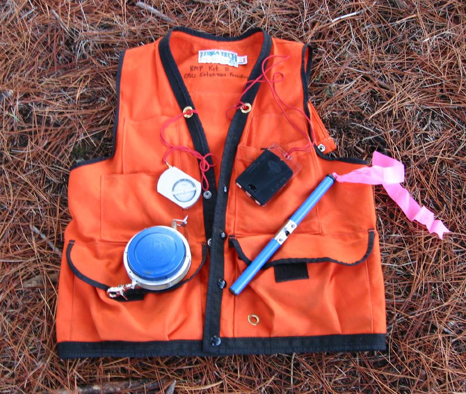
Woodland owners routinely want to measure property acreage, boundaries, ground slope, standing timber characteristics, and individual log volumes. Different tools are required for each of these tasks (Figure 1).
Forests and forest products can be measured efficiently and accurately with sophisticated and often expensive instruments. However, most measurements can be made with a few simple and inexpensive tools.
This publication discusses only tools that are readily available, affordable, and appropriate for a woodland owner who has basic measurement skills. Table 1
compares the accuracy and convenience of each tool.
The tools and how they work
Angle gauges and prisms
These are mechanical or optical devices for measuring the basal area of trees in variable-plot radius sampling where the size of each plot varies depending on the size of the trees in that plot. The most common is a wedge prism, which is a precisely ground glass wedge calibrated in basal area factors from 10 to 70 (20 to 40 will meet most small woodland owners’ needs). Another option for measuring basal area is an angle gauge. These simple and inexpensive tools cover multiple basal area factors. For more information on using variable radius plots, refer to Basic Forest Inventory Techniques for Family Forest Owners (PNW 630) in the OSU Extension Catalog (https://catalog.extension.oregonstate.edu/pnw630).
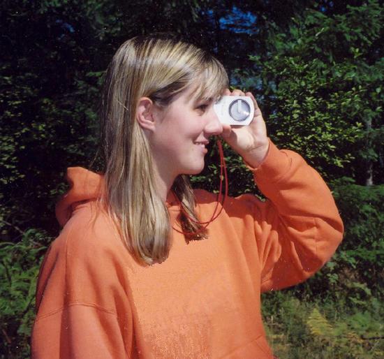
Clinometer
A rugged, hand-held instrument, a clinometer measures vertical angles, such as ground slope, road grade, and tree height (Figure 2). Various models have degree and percent scales, percent and topographic scales, or degree and topographic scales. The best models have degree and percent scales. When using the percent scale at a distance of 100 feet from the tree, you can measure heights. You can also read ground slope with this tool. To ensure accurate slope measurements, make certain your measurement target is at eye level.
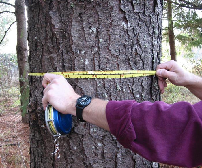
Combination logger’s tape
These steel tapes have a spring-loaded spool rewind and contain measurements in various combinations on both sides of the tape. The best tapes have a diameter measurement tape in inches and tenths of inches on one side and length in feet and tenths of feet on the other. If a tape is used for bucking logs, it is best to have a tape that measures feet and inches rather than tenths of feet (Figure 3) because these units are used when selling logs. Standard tapes come in 50-, 75-, and 100-foot lengths. The 50-foot tape is best for logging, and the 100-foot tape is best for tree measurements. The horseshoe nail will hold the end of your logger’s tape in place while you take the measurement. When you’re done, a gentle tug will release the nail and the tape will rewind.
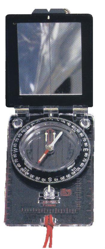
Compass
A hand-held compass is a rugged instrument that measures direction in degrees (Figure 4). Compasses are often used when following transect lines to establish plots for timber measurements or cruise estimates and in determining boundary or property lines. Holding the compass level will give more accurate readings. A compass with a mirror allows the user to view the compass dial and the target at the same time for additional accuracy. Compasses are available in azimuth (0–360 degrees) or quadrant (0–90 degrees). Most woodland owners find the azimuth compass easier to use.
Global Positioning System
GPS is a utility that provides users with positioning, navigation, and timing services. It uses a constellation of 24 satellites transmitting accurate time and position data day and night. Satellite signals are broadcast to hand-held units to calculate the users’ position and time. Hand-held units vary in cost from $75 for consumer-grade receivers up to tens of thousands of dollars for survey-grade instruments (Figure 5). Many mobile devices such as smartphones have GPS receivers.
Inexpensive receivers and smartphones can be inaccurate—especially when trees or other obstacles block satellite signals. However, these devices can make rough length or area measurements or be used for navigation in the field. More accurate measurements, such as those involving property boundaries, require trained and licensed surveyors using professional GPS receivers. High-end units are typically too expensive for the average woodland owner.
Increment borer
This is a hand-operated drill with a hollow bit and core extractor that removes a wood core from the stem of a tree (Figure 6). Wood core samples help determine tree growth, age, and general health. Borer lengths vary in 2-inch increments, from an 8-inch minimum to a much larger sampling depth. The largest is adequate for conveniently determining the age of trees up to about 30 inches in diameter (including bark). Most woodland owners use the 8-, 10-, or 12-inch borers. Longer borer lengths take additional physical effort to extract a wood core.
Log volume tables
These tables range from single sheets to an entire book listing log volumes for each log length and scaling diameter. Tables are available for a number of board-foot and cubic-foot scales. The OSU Extension publication Measuring Timber Products Harvested from Your Woodland (EC 1127, available at https://catalog.extension.oregonstate.edu/ec1127) is a good source for log volume tables.
Mobile apps
Several mobile apps can help you manage your woodland property. For example, mapping apps use your device’s GPS to locate you even if you are out of network range or Internet access. These apps allow you to view your location on maps you upload yourself or to work with a preloaded base map of your property. You can display the map and your current location and record important points and routes on the device’s screen. Some apps help generate timber cruises based on data you collect from your property, while others identify tree species or work as a compass or clinometer. These apps vary in accuracy, and many charge a fee for advanced features. For more examples of apps and their descriptions, visit the Southern Regional Extension Forestry website at https://sref.info/resources/mobile-apps.
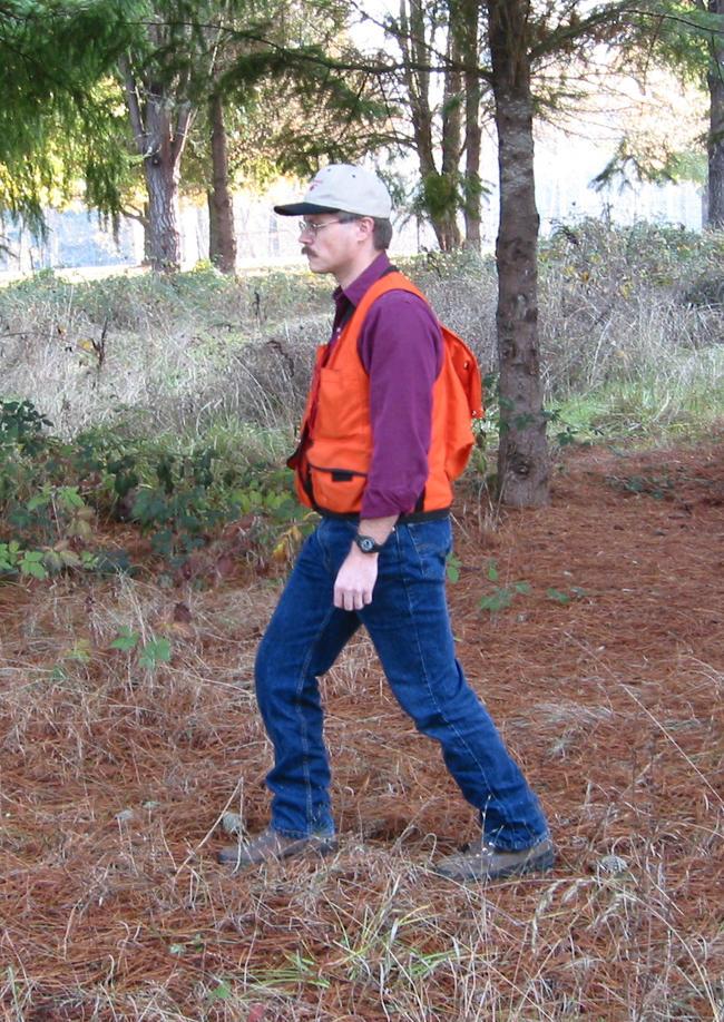
Pacing
This is a skill rather than a tool, but it commonly replaces tools when horizontal distance measurements do not need to be accurate (Figure 7). The best way to determine your pace is to count your steps as you walk an accurately measured distance using the same kind of pace you use for everyday walking.
Rangefinder
Laser rangefinders accurately measure distances using a beam of light. Most units designed for forestry also include a digital clinometer. With this feature, a rangefinder can be used to measure horizontal and slope distance and tree heights. Some units include a setting to recognize a reflective target—a handy option for measuring distances in brushy conditions. Laser rangefinders cost $250 or more. The price depends on the number of features and the device’s accuracy.
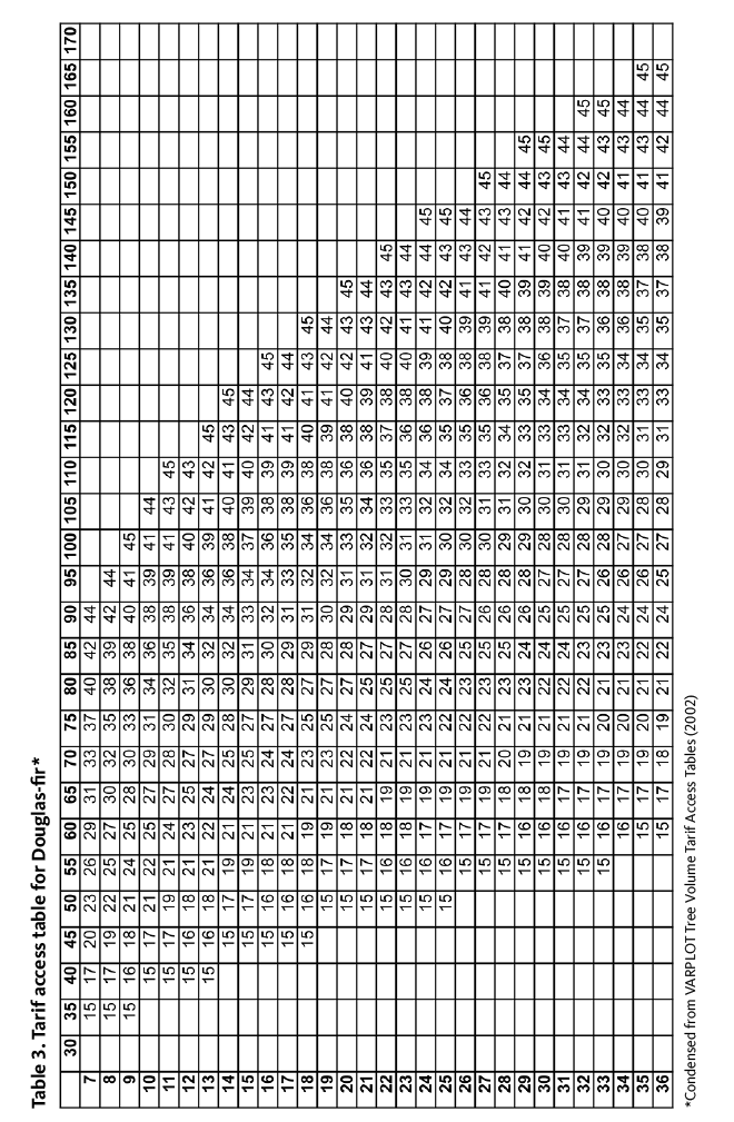
Tarif access tables
These tables list the tarif number for individual tree species, such as Douglas-fir (Table 3), based on tree height and the diameter at breast height. Tarif is a ratio of a tree’s volume to its basal area, so a low tarif number means the tree has much taper. A high tarif number means it has minimal taper. For details, see the OSU Extension publication Measuring Your Trees (EM 9058), available at https://catalog.extension.oregonstate.edu/em9058.
Topographic map
These maps show terrain (ridges, draws, and flat areas) with contour lines. The contour lines indicate locations of equal elevation and make it possible to measure the slope of the ground from the map. Widely spaced contour lines indicate flat or gentle ground; closely spaced lines indicate steep ground.
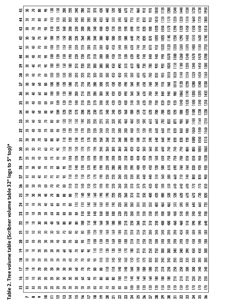
Tree volume tables
These tables list the wood volume of individual tree species in board-foot or cubic-foot volumes.
Table 2 is based on tarif number, log length, and diameter at breast height for each tree. More tree volume tables are in Measuring Your Trees (EM 9058), available at https://catalog.extension.oregonstate.edu/em9058.
The Woodland Stick
Several sticks or other devices help you simply and accurately estimate tree height and diameter (Figure 8). The Woodland Stick also has an abbreviated log volume table for estimating log volumes in standing trees. This tool is also known as a Biltmore Stick. The OSU Extension Woodland Stick includes additional information, such as a Douglas-fir thinning guide, east- and west-side management guide, a reforestation spacing formula, cross-drainage spacing, common fixed-plot radii, Scribner log volume table, canopy classes, and a useful conversion table. This tool is available for purchase from the OSU Forestry Extension program or from your county Extension office.
Comparing tools
Use Table 1 to compare tools that can be used for similar tasks. The table uses three numbers to indicate the degree of accuracy and the degree of difficulty for using each tool. Determine what you want to measure and consider all the tools in the left column. Some are quick and easy to use but yield less accurate results. Others are more difficult to use but may not give more accurate results.
Select a tool that fits the objective. For example, if you want to measure a road grade, you can choose between a clinometer and a topographic map. The clinometer is rated a 2 for accuracy, which means it is moderately accurate, and 2 for ease of use
The topographic map is rated 1 for accuracy in measuring road grade, which means it’s less accurate than the clinometer, and 2 for ease of use (moderately easy to use). These ratings mean the clinometer is more accurate than a topographic map but is equally easy to use.
Most tools discussed here are available from local forestry supply stores or from online retailers. An Internet search for “forestry supplies” will yield several options. Tool and supply catalogs are also available in OSU Extension offices in many counties.
A new tool usually comes with instructions, but novices often need help with certain instruments. Ask the forester in the OSU Extension office nearest you for additional publications or sources of assistance.
For more information
Oregon State University Extension Service publications available online at https://catalog.extension.oregonstate.edu. Key publications for woodland owners include:
- Measuring Your Trees (EM 9058) https://catalog.extension.oregonstate.edu/em9058
- Tarif Access Tables: A Comprehensive Set (EM 1609) https://catalog.extension.oregonstate.edu/ec1609
- Measuring Timber Products Harvested from Your Woodland (EC 1127) https://catalog.extension.oregonstate.edu/ec1127
- Land Measurement and Mapping: An Introduction for Woodland Owners (PNW 581) https://catalog.extension.oregonstate.edu/pnw581
- Basic Forest Inventory Techniques for Family Forest Owners (PNW 630) https://catalog.extension.oregonstate.edu/pnw630
- GPS: the Global Positioning System (https://www.gps.gov/)
|
Table 1. Rating and convenience of tools for various measuring tasks |
|||||||||||||||
|
Accuracy 1= less accurate 2 = moderate 3= more accurate Ease of use 1 = difficult to use 2 =moderate 3= easy to use |
Measurement Tasks |
||||||||||||||
|
Boundaries |
Logs |
Trees |
|||||||||||||
|
Area |
Horizontal angles |
Horizontal distance |
Road grade |
Ground slope |
Diameter |
Length |
Volume |
Age |
Basal area |
Current growth |
Diameter |
Volume |
Height |
||
|
Angle gauge ($) |
Accuracy |
2 |
|||||||||||||
|
Ease of use |
2 |
||||||||||||||
|
Clinometer ($$) |
Accuracy |
2 |
2 |
2 |
|||||||||||
|
Ease of use |
2 |
2 |
2 |
||||||||||||
|
Compass ($) |
Accuracy |
2 |
|||||||||||||
|
Ease of use |
2 |
||||||||||||||
|
Global Positioning System* ($$-$$$) |
Accuracy |
3 |
2 |
3 |
1 |
||||||||||
|
Ease of use |
1 |
1 |
1 |
1 |
|||||||||||
|
Increment borer ($$$) |
Accuracy |
3 |
3 |
||||||||||||
|
Ease of use |
2 |
2 |
|||||||||||||
|
Logger’s tape** ($$) |
Accuracy |
2 |
2 |
3 |
3 |
3 |
|||||||||
|
Ease of use |
2 |
3 |
3 |
3 |
3 |
||||||||||
|
Log volume table ($) |
Accuracy |
3 |
|||||||||||||
|
Ease of use |
3 |
||||||||||||||
|
Pacing ($) |
Accuracy |
1 |
1 |
||||||||||||
|
Ease of use |
3 |
3 |
|||||||||||||
|
Rangefinder ($$$) |
Accuracy |
3 |
2 |
2 |
|||||||||||
|
Ease of use |
2 |
2 |
2 |
||||||||||||
|
Tarif access tables*** ($) |
Accuracy |
3 |
|||||||||||||
|
Ease of use |
2 |
||||||||||||||
|
Topographic map ($) |
Accuracy |
1 |
1 |
||||||||||||
|
Ease of use |
2 |
2 |
|||||||||||||
|
Woodland stick ($) |
Accuracy |
2 |
2 |
1 |
2 |
||||||||||
|
Ease of use |
3 |
3 |
3 |
3 |
|||||||||||
|
Map apps ($) |
Accuracy |
2 |
2 |
1 |
|||||||||||
|
Ease of use |
2 |
2 |
3 |
||||||||||||
|
Cost: $ =$0—$50; $$ = $50–$100; $$$ = $150+ * Global Positioning Systems come in a wide price range. Expensive models are typically more accurate. ** Logger’s tape cartridges come with feet and inches on one side and tree diameter (inches) on the other side. *** Tarif access tables include tarif tables for individual species and a tree volume table. |
|||||||||||||||
Extension work is a cooperative program of Oregon State University, the U.S. Department of Agriculture, and Oregon counties. Oregon State University Extension Service offers educational programs, activities, and materials without discrimination on the basis of race, color, national origin, religion, sex, gender identity (including gender expression), sexual orientation, disability, age, marital status, familial/parental status, income derived from a public assistance program, political beliefs, genetic information, veteran’s status, reprisal or retaliation for prior civil rights activity. (Not all prohibited bases apply to all programs.) Oregon State University Extension Service is an AA/EOE/Veterans/Disabled.
About the authors